Incredible one-day trip and my first time down the T. We were carefully watching the winter storms rolling through and waited for a perfect window. The T was hovering around 3k and a sunny Saturday was in the forecast. I called a friend and he recommended:
1) Arrange a shuttle
2) Be careful if it goes above 6k
3) Watch out for Grey’s Grind Stone at high flows.
All was helpful beta. We put-on at 11AM and took out by 5 PM. Drinking beers at the Iron Door by 6:30.
Big Timber creek defines the Crazy Mountains perfectly. Located 2 hours outside Bozeman, Big T flows directly out of the crazies. It’s rugged, scenic, and steep. Very steep, average gradient around 700 FPM. Whether or not you plan to run the creek the adventure is rewarding, it is well worth the hike for the beautiful waterfalls and granite slabs.
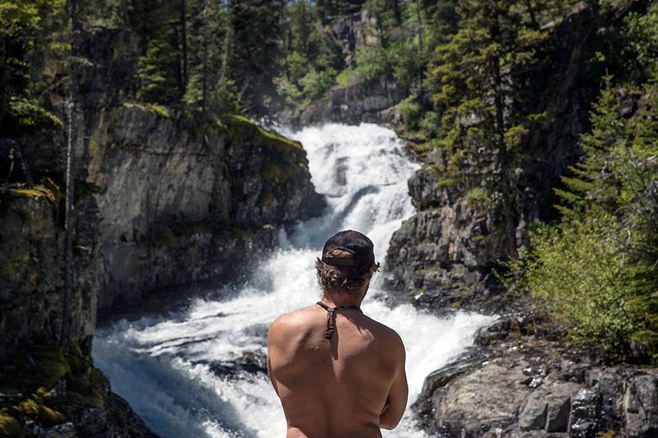
We initially hiked up the creek to scout the drops to see if it is actually possible to run it with a raft. About a half mile up the trail is Big Timber Falls. Big T falls is the burliest of the Timber Creek drops, it gives a good indicator of what’s ahead, long technical slides.
Scouting Big Timber Falls.
With a nervous walk we hiked another mile up the creek and arrived to a walking bridge, this is marker for the upper section take out. Another mile or so up is the classic Big Timber drops, the pinch, gambler, and plenty of other rapids in between. As we hiked up the trail we scurried down the creek to scout each and every drop. After getting our imagination pumped with excitement we decided to run back to the truck, and carry the raft up 3 miles.
We brought the boat to the bottom of the Pinch rapid. The Pinch is a fast, long drop, as the name indicates the rapid “pinches at the bottom” into a tight slot. Garrett and I decided to lower the boat directly below the pinch.
Once in the raft, Garrett and I took a deep breath and pushed off. From the start it was game on and spicy. Muy caliente.
Directions For Fun: From Bozeman drive on East I-90 towards the town of Big Timber (55 miles), at the town you want to connect to North 191 towards Half Moon Campground (26 miles). Beautiful drive on a bouncy dirty road, takes about an hour. At the campground is a parking lot for day hikers. Follow the trail up the creek. Half mile up the creek is a sign which point towards Big T Falls. Another mile up is a walking bridge across the creek. The bridge marks the take-out for the upper section. As the trails gains elevation you can walk down towards the creek to scout all the fun slides. Look at the drops for wood and safety.
When the Bitterroot River is between 1K to 3K cfs, Kootenai Creek will be at a good level.
My good friend Nate Moody and I were looking for a specific adventure. As Middle Fork Salmon river guides we had limited time. First, we wanted to find a creek with an easy hike to class V whitewater. Second, at least one waterfall. Lastly, a brewery in close proximity to drink to our mini adventure. Granted, a lot to ask for, yet Kootenai Creek delivered on all three wishes.
From Salmon, Idaho we drove north on US-93 towards Victor, Montana. Took about 2 hours. 15 minutes or so past Victor, signs pointed us to the Kootenai trailhead, 5 minutes driving on dirt and boom we were there.
Before we geared up, we decided to hike up the trail to scout out the fun ahead; 400 yards from the parking lot we saw glorious whitewater. We continued another 3/4th of mile up to a 10ft waterfall. Below the drop, was a series of steep slides with many boofs and necessary moves. The final drop was a huge airplane turn into a big slide. The run looked about 1 mile long, and at least 250 FPM. Nervous and stoked, we ran back to the truck.
Scouting the run. Photo by Skip Volpert.
I decided to run the waterfall and Nate set safety below. A couple things about the 10 footer. The current above the drop is deceiving, there’s a diagonal wave which pushes left into a nasty room of doom against a rock. Basically, half the drop goes into this rock. Not good. I boofed as far right as I could to avoid the rock. Below the drop, it was game on. The creek was incredibly fast, giving us no time to eddy out till the last drop. At the bottom of the final drop, we had shit smiling grins and both of us decided to give it another go! 10 minute hike back up to the put-in and we did it again. And then again.
Pumped from Kootenai, we drove to the Bitterroot Brewery in Hamilton and eased our adrenaline with some tasty IPA’s. A successful day.
Making the move on the final drop. Photo by Skip Volpert.Hitting the final drop. Photo by Skip Volpert.
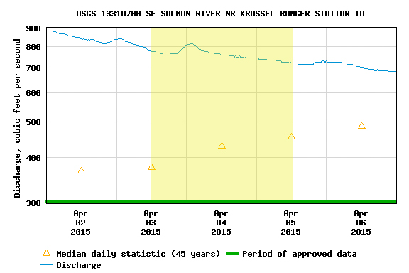
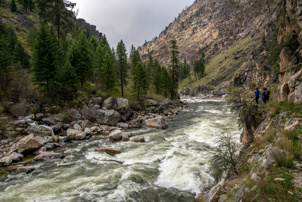
The level was 3.69 Ft. Guides from the Middle Fork of the Salmon River decided to check out the other side of the Frank Church. Andrew Wilkin, Kevin Widerman, Colin Hughes, and Josh Edmunson. We did a 3 day, 2 night raft trip. First night we Camped at mile 14.7 on river left, above Mule Kick. Second night at the confluence of the Main Salmon. 14ft boats are a perfect size raft for this level. Enjoy the report below!
For Oregon Boaters, I would compare the SF Salmon to the Illinois. It’s a run I’d describe as “land of the giants,” big holes lurking, huge horizon lines, and long continuous rapids with necessary moves. Similar to the logistics of the Illinois, the remoteness, shuttle, and changing flows make it difficult, but very doable for those who are motivated!
I would recommend 2.5ft to 3.7ft. Anything above 3.7, be careful.
Once you have the gauge figured out, then you should organize a shuttle. Google the shuttle companies in the area, or call a friend from McCall.
I like to break the SF into 3 sections. The first section is the put-in (confluence of the Secesh river) to Mule Kick rapid (mile 15). Second section, Mule Kick (Mile 15) to the Saw Mill (Mile 23), then the Saw Mill (mile 23) to Fall Creek rapid (Mile 32), the last big rapid on the South Fork.
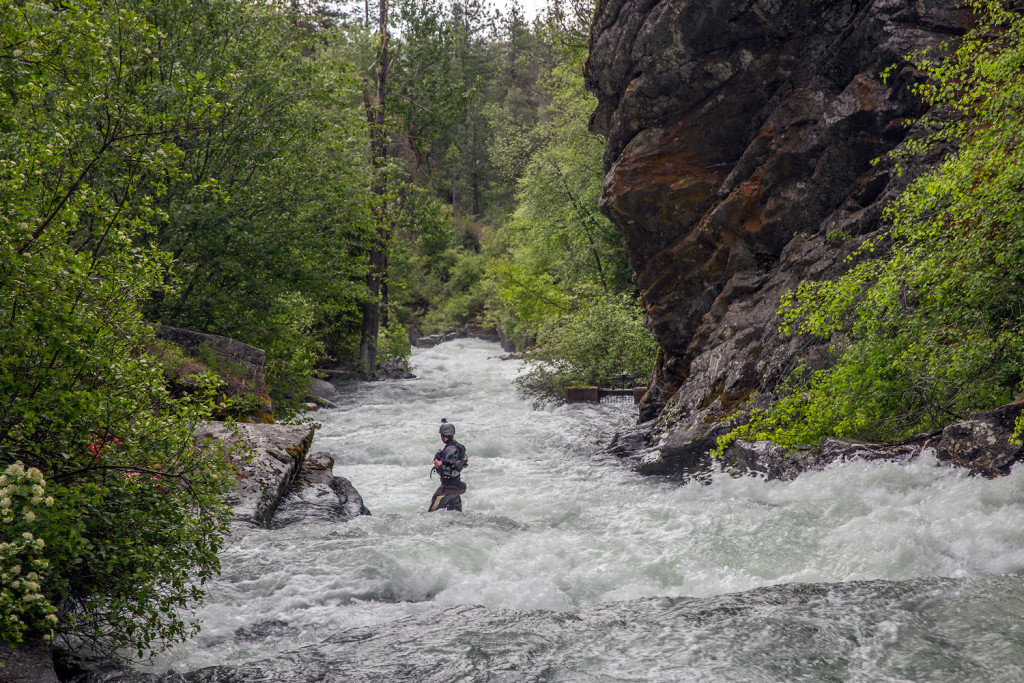
Section 1: From the put-in to Devils creek, be on your toes, lots of fun class III-IV boogie water. In no time you’ll be at Devils Creek, the first significant rapid at Mile 9. Scout on the left. Devils creek is a tricky rapid, which has a history of wood being stuck in it. Make sure you scout and really inspect the last part of the drop. After Devils Creek, is a continuous set of read and run class III-IV. Be alert and ready to make moves, some rapids you will just have to just square and push through the big hits. Around mile 14ish is a stretch of sand bar camps on river left. Nice spot to stay, above the next set of rapids.
Entrance to Devil’s Creek. Photo by Skip Volpert.Devil’s Creek on the South Fork Salmon. Photo by Skip Volpert.
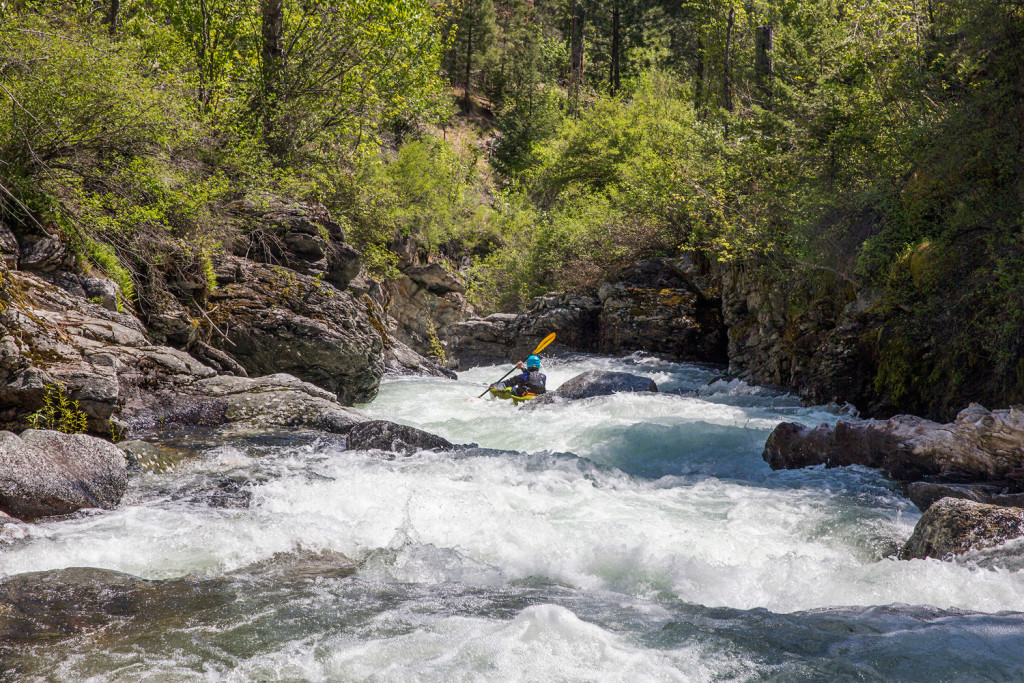
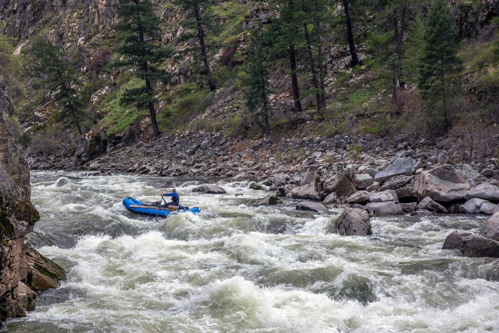
The second section: Mule Kick (mile 15) to the Saw Mill (mile 23). It’s tough for me to remember all the names of the rapids, just know there’s a plethora of rapids. I would recommend scouting most, if not all of them. Scout Mule Kick on the left, there’s a big pool above. Make sure to look for an eddy on river left below the rapid, Elk Creek is around the corner. Below Elk Creek is a spicy noodle plate of rapids. Be careful, hit em straight.
The Sawmill at Mile 23. Photo by Skip Volpert.
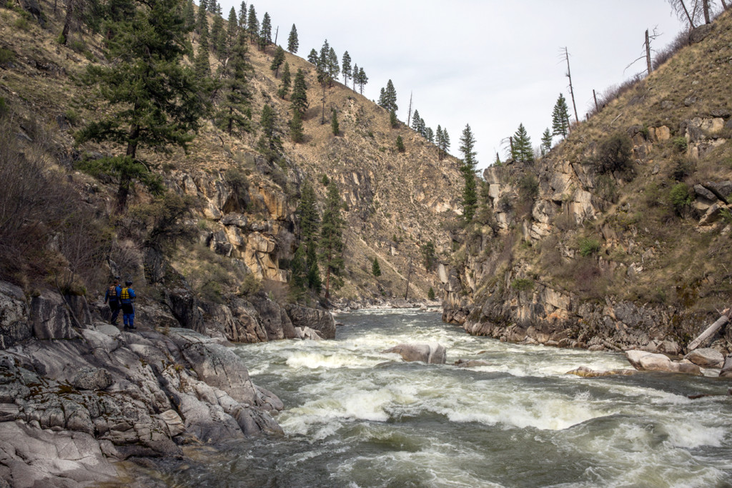
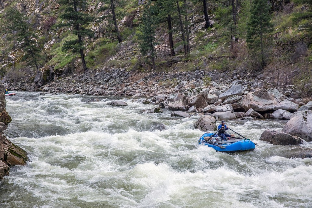
The third section, the Lumber Mill (mile 25ish) to the Confluence (mile 36.2). As the river begins to mellow, below Grouse Creek, you’ll notice a huge sawdust burner [note: we originally called this a “steam boiler” (see Ken’s comment at bottom of page)] on river left. Awesome structure to explore and check out. Note, the first rapid below the lumber mill is a technical class IV-V rapid. Far left is a undercut. No Bueno. Go center. After a couple more fun rapids the canyon will begin to narrow and you’ll be entering the last big section of the SF, buckle up!
Once you enter the canyon the gradient will increase significantly. Lots of rapids. Near the end of the stretch, is Monumental rapid (mile 31). Run hey diddle diddle right down the middle, some big hits to be had. This is a key rapid to note. Below monumental rapid is the scout eddy for Fall Creek. The scout is on the right, there’s small sandbar with a noticeable trail.
First part of Fall Creek. Photo by Skip Volpert.
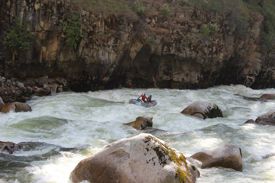
Fall creek is a 3 part rapid. You will want to scout all the drops. Once you push off in your boat it can be difficult to stop above the last drop. The Main Salmon confluence is at mile 36.4. You can spend the night at the confluence, and then float out the next day. Note, you’re not allowed to camp on the Main Salmon. From the confluence to the Main Salmon take-out is 23 miles. Drink beers and celebrate good times!
Making the move in the first part of Fall Creek. Photo by Skip Volpert.Success! Photo by Skip Volpert.Last drop in Fall Creek. Photo by Skip Volpert.
If Panther Creek was in California, Oregon or Washington this would be a coveted whitewater run. Instead, the creek is tucked away near the Frank Church Wilderness in Idaho. Spending my summers in Salmon this stretch is more feasible to run, but still a long drive.
From Salmon, drive to the town of North Fork via US-93 North, at the town turn left on to the Salmon River Road. From North Fork it’s about an hour to Panther Creek. The creek flows into the Salmon river on river-left. Follow an old dirt mining road up the creek for about 20 miles. You will definitely know when you get to the big section. It’s about 2 miles long, two distinct class V rapids class, and daunting.
We spent a long time scouting the run. The only eddy is between the big rapids. It was important to note all the big features and ensuing moves. Wasn’t pretty, but we made it down. Stoked to do it again next spring. At low water Panther Creek is an excellent dry fly creek, comparable to Fly Fishing on the Middle Fork Salmon
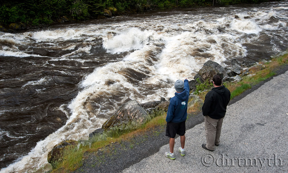
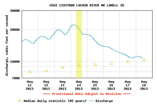
As the saying goes, “there’s more than one way to skin a cat,” the same can be said for running Lochsa Falls at high water. Twice in the last three years, the Lochsa has peaked just above 20K (9ft), making the run a good old hootenanny. This coming spring looks to be just as promising. And with the big water will come the carnage at Lochsa Falls.
When I first scouted Lochsa Falls the level was 20K on the gauge. The V wave at the Falls looked intimidating and something I wanted to avoid. This notion was quickly proved wrong. As we were scouting from the road, an oar rig with two paddle assist came in charging hard into the V wave. The oarsmen knew exactly what he was doing; he was moving from river right to the left, and angled directly towards the left side of the crashing V wave. He had a perfect line smooth as butter, no one in his boat got wet.
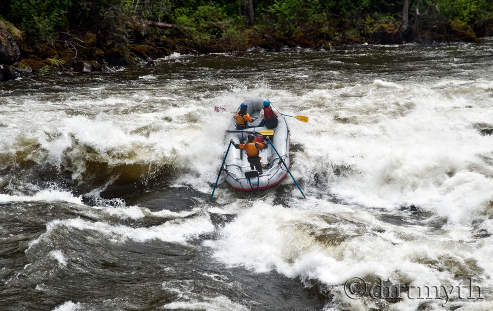
Rafting Lochsa Falls on the Lochsa River, Idaho.
Still, I was nervous so I went with the more conservative line, left of center. The Lochsa veterans called the move “Satan Gut” line. The line is to enter left-of-center and continue to work left while threading the needle between big holes on both sides of you.
A year later I tried the right of center-line. When I came into the wave, I noticed it was building and building, and on cue it crashed directly on my boat. Like a stop light, the wave went from Green to Red in an instant. Stopped us dead, surfed us, then flipped the boat. We had no chance.
For the boatmen, for the thrills, but really just for the rivers
We use cookies on our website to give you the most relevant experience by remembering your preferences and repeat visits. By clicking “Accept All”, you consent to the use of ALL the cookies. However, you may visit "Cookie Settings" to provide a controlled consent.
This website uses cookies to improve your experience while you navigate through the website. Out of these, the cookies that are categorized as necessary are stored on your browser as they are essential for the working of basic functionalities of the website. We also use third-party cookies that help us analyze and understand how you use this website. These cookies will be stored in your browser only with your consent. You also have the option to opt-out of these cookies. But opting out of some of these cookies may affect your browsing experience.
Necessary cookies are absolutely essential for the website to function properly. These cookies ensure basic functionalities and security features of the website, anonymously.
Cookie
Duration
Description
cookielawinfo-checkbox-analytics
11 months
This cookie is set by GDPR Cookie Consent plugin. The cookie is used to store the user consent for the cookies in the category "Analytics".
cookielawinfo-checkbox-functional
11 months
The cookie is set by GDPR cookie consent to record the user consent for the cookies in the category "Functional".
cookielawinfo-checkbox-necessary
11 months
This cookie is set by GDPR Cookie Consent plugin. The cookies is used to store the user consent for the cookies in the category "Necessary".
cookielawinfo-checkbox-others
11 months
This cookie is set by GDPR Cookie Consent plugin. The cookie is used to store the user consent for the cookies in the category "Other.
cookielawinfo-checkbox-performance
11 months
This cookie is set by GDPR Cookie Consent plugin. The cookie is used to store the user consent for the cookies in the category "Performance".
viewed_cookie_policy
11 months
The cookie is set by the GDPR Cookie Consent plugin and is used to store whether or not user has consented to the use of cookies. It does not store any personal data.
Functional cookies help to perform certain functionalities like sharing the content of the website on social media platforms, collect feedbacks, and other third-party features.
Performance cookies are used to understand and analyze the key performance indexes of the website which helps in delivering a better user experience for the visitors.
Analytical cookies are used to understand how visitors interact with the website. These cookies help provide information on metrics the number of visitors, bounce rate, traffic source, etc.
Advertisement cookies are used to provide visitors with relevant ads and marketing campaigns. These cookies track visitors across websites and collect information to provide customized ads.


 When the Bitterroot River is between 1K to 3K cfs, Kootenai Creek will be at a good level.