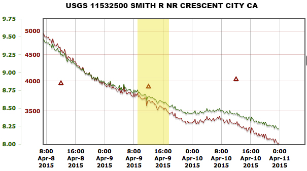
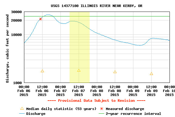
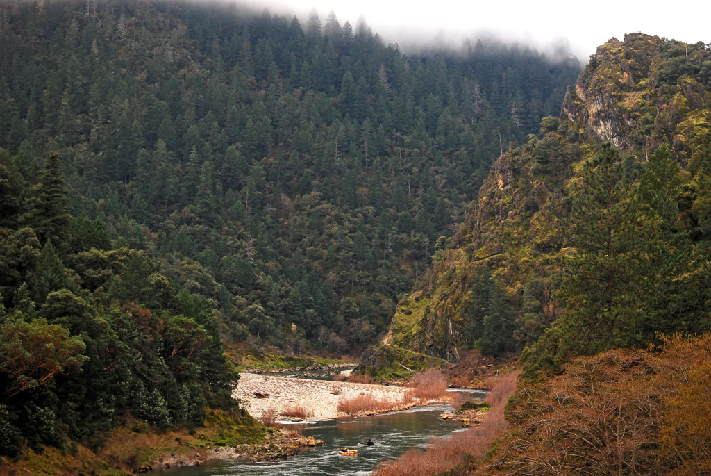
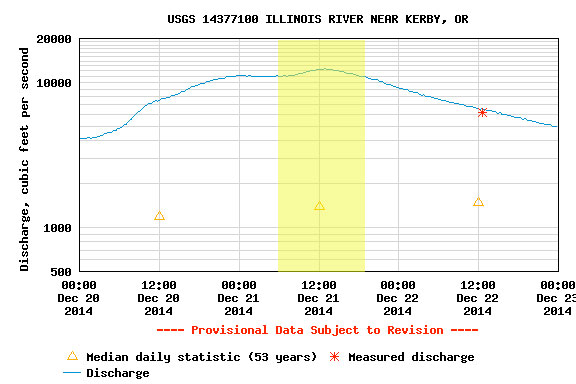
Zach Urness had been bugging me about getting back on the North Fork of the Smith. We had low flows but beautiful weather. The gauge above shows flows at Jed Smith, which are reported in CFS and Feet. This is a different gauge than the one Bearfoot Brad reports (which is at the actual confluence of the NF and MF Smiths) but the one above is the official USGS gauge. The gauge at the mouth of the NF is a foot gauge that is meant to correlate with the USGS gauge at Jed Smith. However, isolated weather events can throw this correlation off, in which case it’s best to use Brad’s gauge.
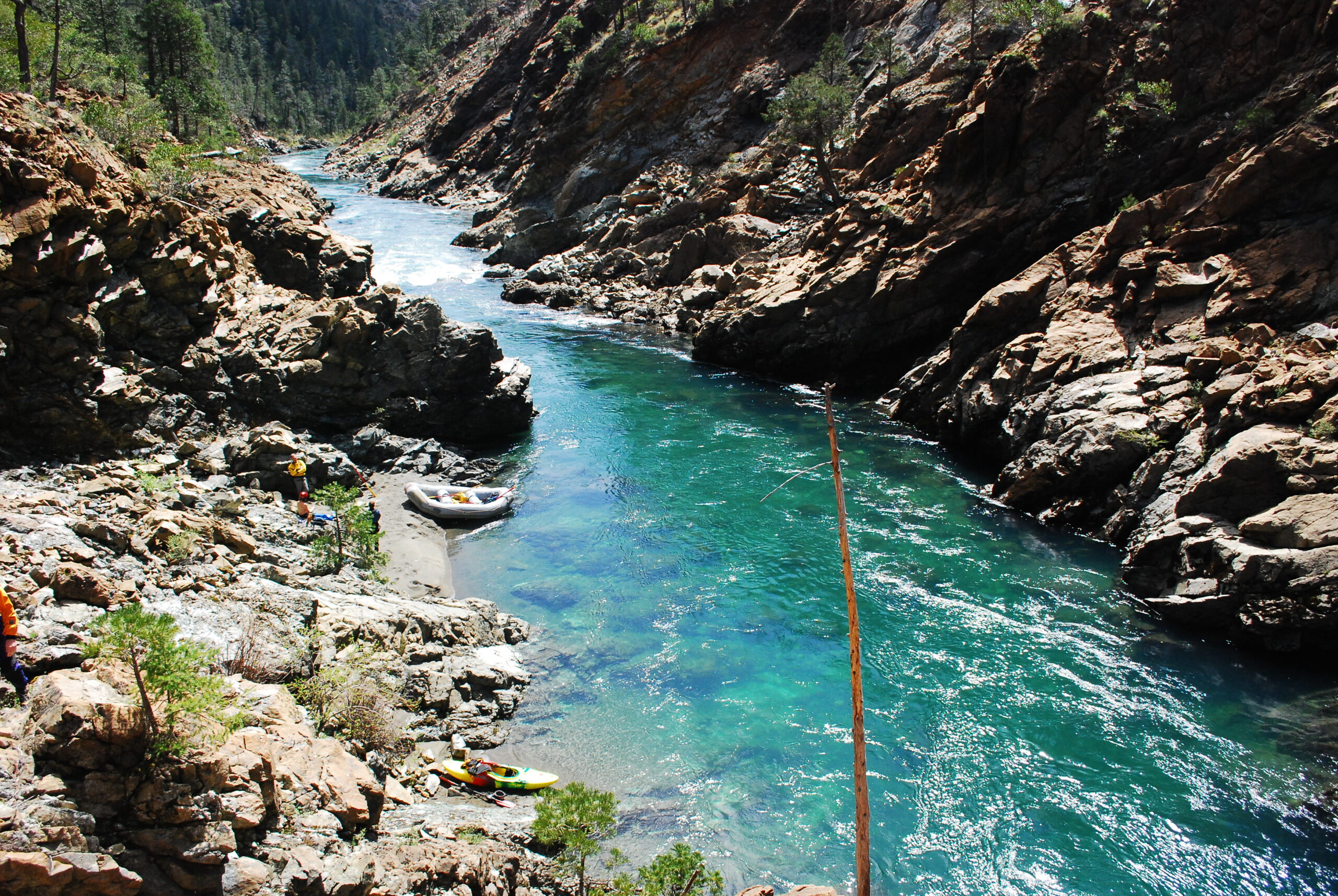
Looking down at Golf Course RapidThe North Fork Smith is a beautiful canyonLooking downstream from the shuttle road
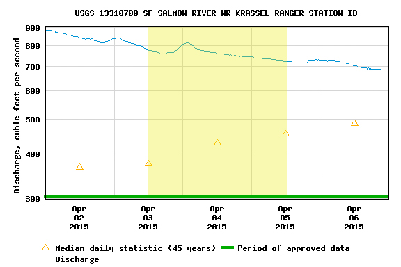
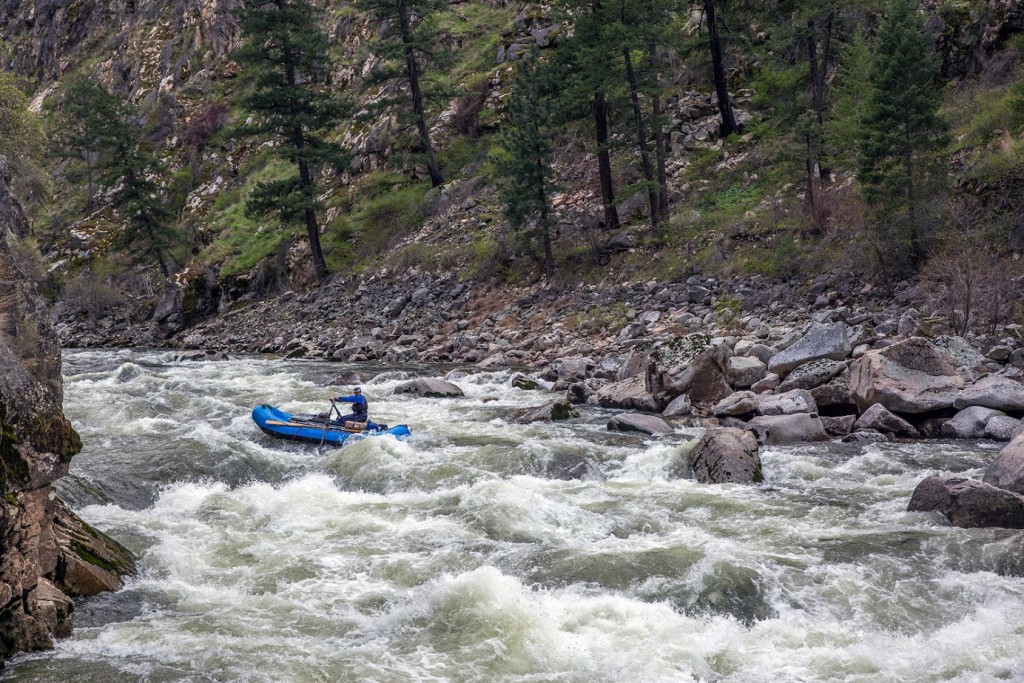
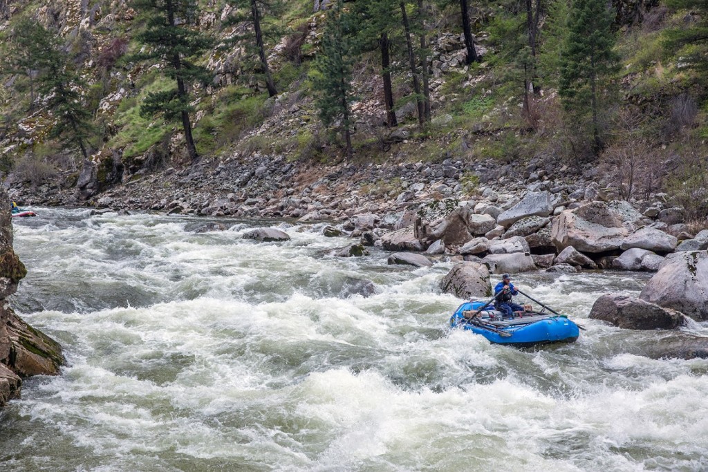
The level was 3.69 Ft. Guides from the Middle Fork of the Salmon River decided to check out the other side of the Frank Church. Andrew Wilkin, Kevin Widerman, Colin Hughes, and Josh Edmunson. We did a 3 day, 2 night raft trip. First night we Camped at mile 14.7 on river left, above Mule Kick. Second night at the confluence of the Main Salmon. 14ft boats are a perfect size raft for this level. Enjoy the report below!
For Oregon Boaters, I would compare the SF Salmon to the Illinois. It’s a run I’d describe as “land of the giants,” big holes lurking, huge horizon lines, and long continuous rapids with necessary moves. Similar to the logistics of the Illinois, the remoteness, shuttle, and changing flows make it difficult, but very doable for those who are motivated!
I would recommend 2.5ft to 3.7ft. Anything above 3.7, be careful.
Once you have the gauge figured out, then you should organize a shuttle. Google the shuttle companies in the area, or call a friend from McCall.
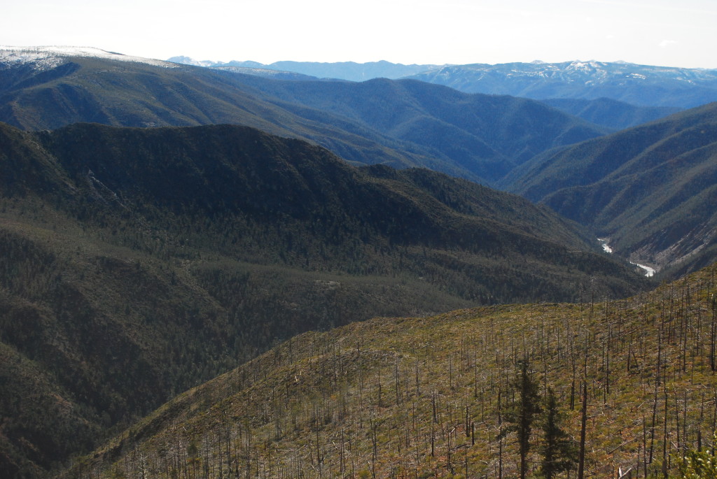
I like to break the SF into 3 sections. The first section is the put-in (confluence of the Secesh river) to Mule Kick rapid (mile 15). Second section, Mule Kick (Mile 15) to the Saw Mill (Mile 23), then the Saw Mill (mile 23) to Fall Creek rapid (Mile 32), the last big rapid on the South Fork.
Section 1: From the put-in to Devils creek, be on your toes, lots of fun class III-IV boogie water. In no time you’ll be at Devils Creek, the first significant rapid at Mile 9. Scout on the left. Devils creek is a tricky rapid, which has a history of wood being stuck in it. Make sure you scout and really inspect the last part of the drop. After Devils Creek, is a continuous set of read and run class III-IV. Be alert and ready to make moves, some rapids you will just have to just square and push through the big hits. Around mile 14ish is a stretch of sand bar camps on river left. Nice spot to stay, above the next set of rapids.
Entrance to Devil’s Creek. Photo by Skip Volpert.Devil’s Creek on the South Fork Salmon. Photo by Skip Volpert.
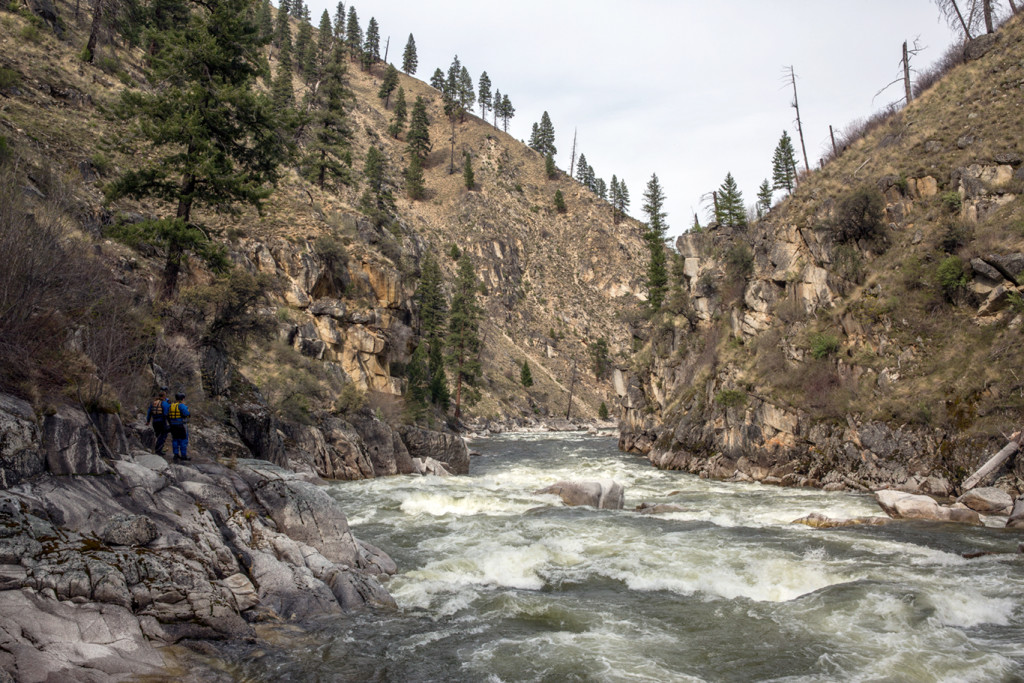
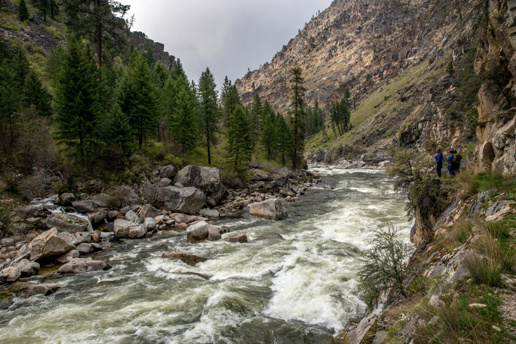
The second section: Mule Kick (mile 15) to the Saw Mill (mile 23). It’s tough for me to remember all the names of the rapids, just know there’s a plethora of rapids. I would recommend scouting most, if not all of them. Scout Mule Kick on the left, there’s a big pool above. Make sure to look for an eddy on river left below the rapid, Elk Creek is around the corner. Below Elk Creek is a spicy noodle plate of rapids. Be careful, hit em straight.
The Sawmill at Mile 23. Photo by Skip Volpert.
The third section, the Lumber Mill (mile 25ish) to the Confluence (mile 36.2). As the river begins to mellow, below Grouse Creek, you’ll notice a huge sawdust burner [note: we originally called this a “steam boiler” (see Ken’s comment at bottom of page)] on river left. Awesome structure to explore and check out. Note, the first rapid below the lumber mill is a technical class IV-V rapid. Far left is a undercut. No Bueno. Go center. After a couple more fun rapids the canyon will begin to narrow and you’ll be entering the last big section of the SF, buckle up!
Once you enter the canyon the gradient will increase significantly. Lots of rapids. Near the end of the stretch, is Monumental rapid (mile 31). Run hey diddle diddle right down the middle, some big hits to be had. This is a key rapid to note. Below monumental rapid is the scout eddy for Fall Creek. The scout is on the right, there’s small sandbar with a noticeable trail.
First part of Fall Creek. Photo by Skip Volpert.
Fall creek is a 3 part rapid. You will want to scout all the drops. Once you push off in your boat it can be difficult to stop above the last drop. The Main Salmon confluence is at mile 36.4. You can spend the night at the confluence, and then float out the next day. Note, you’re not allowed to camp on the Main Salmon. From the confluence to the Main Salmon take-out is 23 miles. Drink beers and celebrate good times!
Making the move in the first part of Fall Creek. Photo by Skip Volpert.Success! Photo by Skip Volpert.Last drop in Fall Creek. Photo by Skip Volpert.
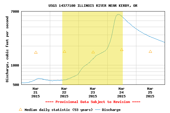
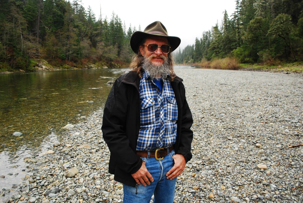
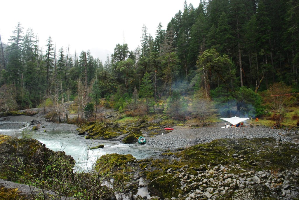
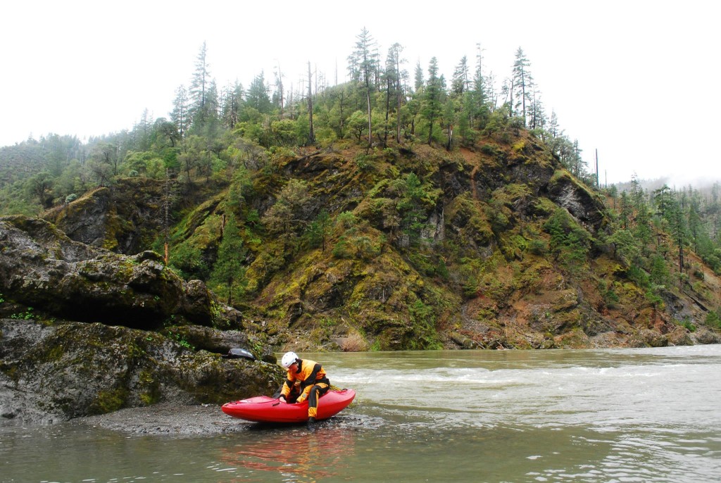
Three days on the Illinois is hard to beat. Three of us met in Selma and headed to the river. The water was a bit low the first day but the rain started coming down and by day two we were floating on a healthy flow. Our first night we camped at Klondike Creek and on night two we stayed at Waterfall.
Famous shuttle driver, Bearfoot BradCamping at Klondike CreekDan Thurber gearing up to leave Waterfall Camp on Day 3
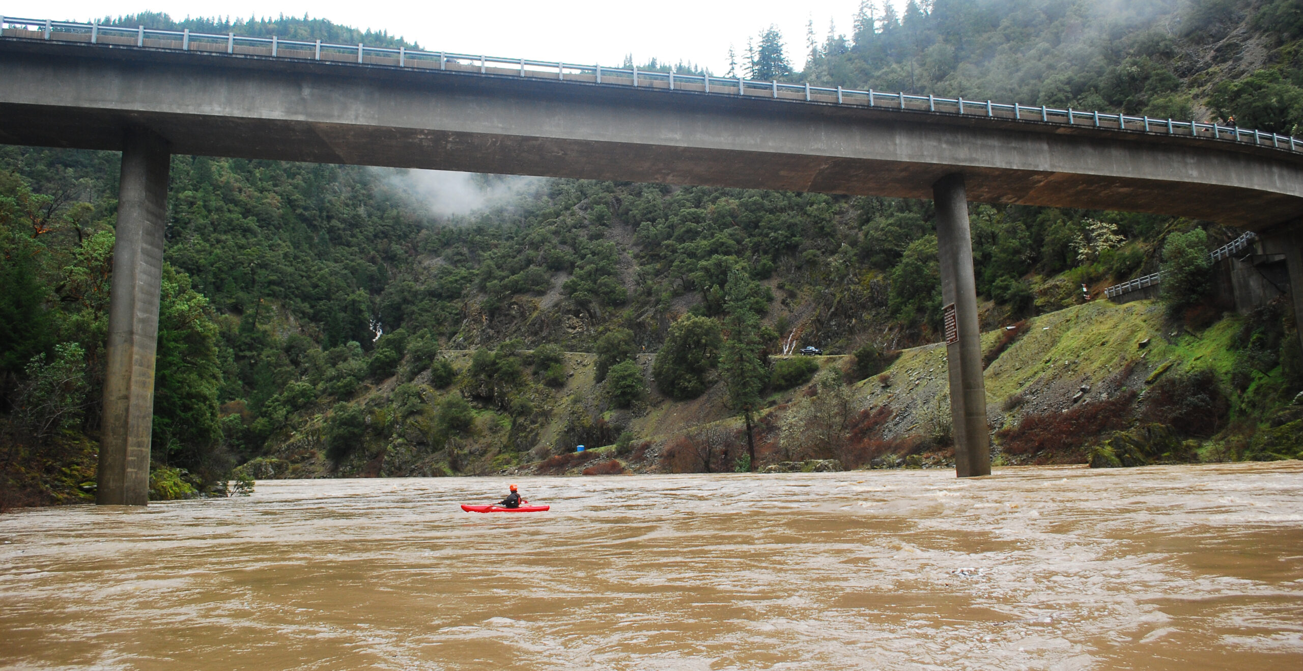
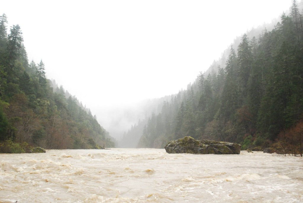
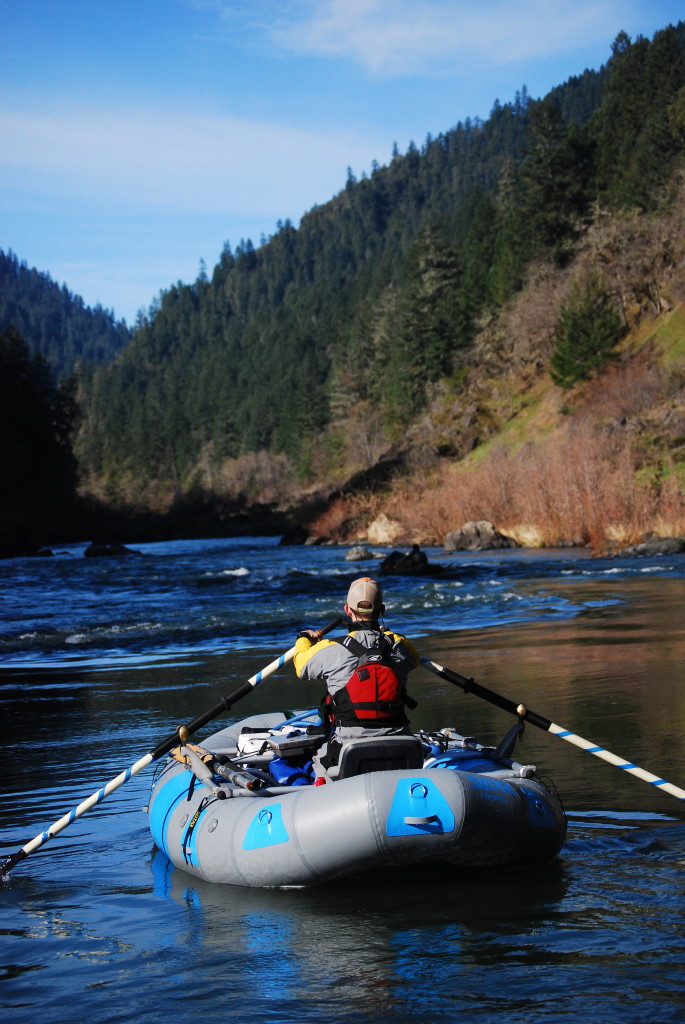
On Saturday, February 7th, three of us pushed off from Almeda on the Rogue River and headed downstream. Four and a half hours later we were at Foster Bar. Here’s what I remember. Thank you to Roger Goth, Aaron Stone, and Erik Weiseth for providing great beta before we pushed off. There are some incredible stories of folks doing this kind of trip back in the day. We were fortunate enough to bring home some photos and video. We weren’t the first, this was not a speed record, but it was an incredible experience.
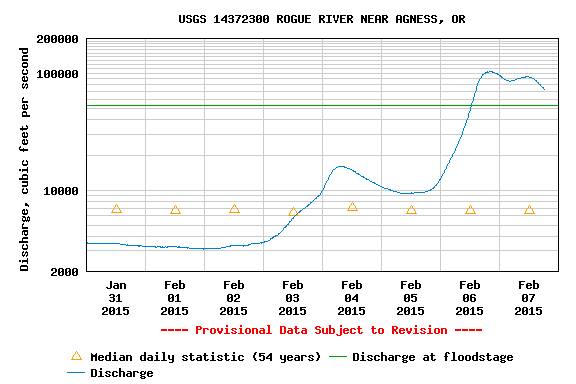
On Friday I was contacted by Aaron Lieberman of Orange Torpedo Trips. He wanted to run the Rogue the following day. He told me I could just show up – no boat needed. I was mainly interested in photographing the river at such a high flow, so it sounded perfect. It peaked at 104,000 c.f.s. in Agness Friday night. I met him at the OTT warehouse in Merlin at 8:00 a.m. Jeanne Fields drove our shuttle. We left OTT around 9 a.m. It was me and Aaron in a raft and Hunter Connolly in a kayak. We pushed off from Almeda at 9:45 a.m.
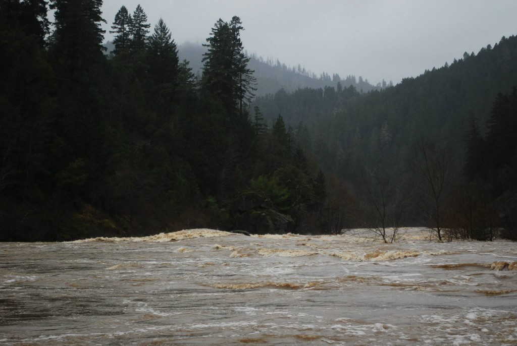
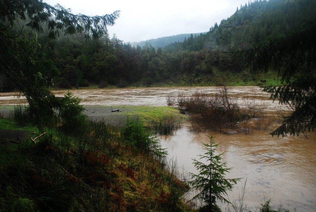
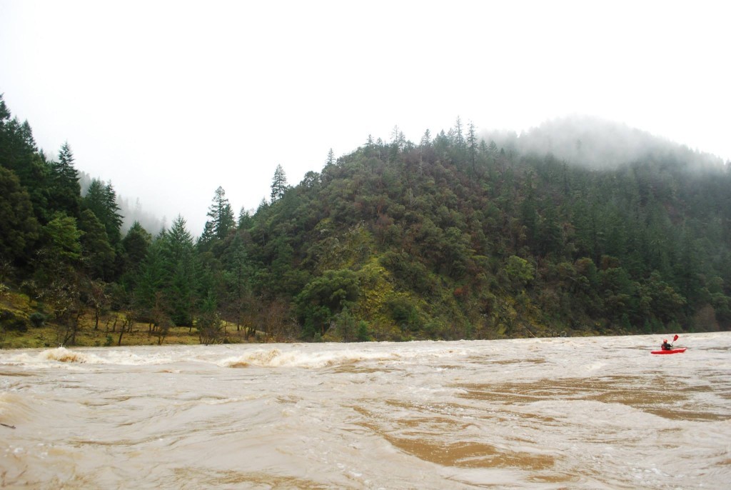
The river was fast and had some scary looking eddies, but it was pretty flat between Almeda and Quail Creek. On the way we stopped at Horseshoe Bend. The water was lapping at the top of the bar. We joked that from now on, we will only camp at Horseshoe at 90k+ CFS because the carry is way easier. The water was so high complete river bends were gone, which made it somewhat difficult to figure out where we were in a few places. There was no indication of Rainie Falls, Upper and Lower Black Bar were literally non existent (no waves or anything), and Sports Illustrated Rock (in the Battle Bar Flats) was sticking out maybe 10 feet. The larger waves and features that we saw seemed to be in places where, at normal flows, there are no rapids. Places that normally have rapids were pretty flat.
Elephant Rock aka Boulder AllyHorseshoe BendSports Illustrated RockHoward Creek enters on the left.
Despite there being very few actual rapids, the rowing was exhausting (mainly to avoid eddy lines and to correct for the unpredictable waves and current) so we switched on and off on the oars. Aaron was rowing when we got to Boulder Ally (there are varying names here, also known as “Elephant Rock”) and the character of the river changed. It went from a relatively calm river to one that felt like it was really flooding. It was a lot pushier. I guess that could be attributed to 1) We probably started on 30,000ish and as we moved downstream volume increased to nearly 90,000 and 2) Maybe the river becomes more constricted in the lower half?
Towards the bottom of Boulder Ally we got pushed to an outside bend and Aaron had to make an incredible hero pull back to the inside to avoid some nastiness. That pull zapped him pretty well, so I jumped on the oars and we were soon taking a quick break at the mouth of Mule Creek. We decided that I would run Mule Creek Canyon and then we would pull over to look at Blossom and Aaron would run Blossom. From what we had heard, Mule Creek Canyon would be under water and the mouth of Stair Creek would have boils. Well, Mule Creek Canyon was under water but the rapid just upstream of the mouth of Stair Creek was huge. We could see some exploding waves and a giant giant giant set of boils on the left. There was a nasty eddy on the right, a huge eddy on the left, and what looked like a thin line of current (moving at about a million miles an hour) in between the two just right of center. I missed to the right and we went for a wild ride on the eddy line on the right. For a split second, a whirl pool grabbed the nose of the boat and I thought we were turning over end-over-end downstream. Here’s a video:
The current grabbed the back of the boat and we were yanked back into the downstream flow. Now things were interesting. The worst eddies we’d seen all day were between Mule Creek Canyon and Blossom. The normal scout for Blossom is on river right. All day long we were trying our best to stick to the inside. We were flying downstream and a left hand bend showed an eddy on the outside. Starting inside, we began the move to the outside and tried breaking through the wave train. It quickly became apparent that catching the eddy probably wasn’t going to happen and if we tried much more and missed we’d be stuck on the outside bend going into Blossom with no idea of what lay ahead. So, a quick change of plans had us pulling back left and missing the giant erratic waves that strung from the right to the center of the river. Stayed left and towards the bottom had to time the move back right to avoid a gnarly swirling eddy that a lot of the current was pushing into.
Stair Creek, Mule Creek Canyon:
Blossom Bar:
Catching take-out at Foster was maybe the most difficult pull of the whole trip because the water was nearly to the toilet but the river right channel was filled with trees. We had to swing way outside initially but Aaron made another great pull and we were soon resting at Foster Bar. Our shuttle arrived 3 minutes later (they had taken the coast route). 4.5 hours from start to finish. I was back in Ashland by 6:00 p.m.
Foster Bar
So that’s the story. Probably wouldn’t do it again, but then again………
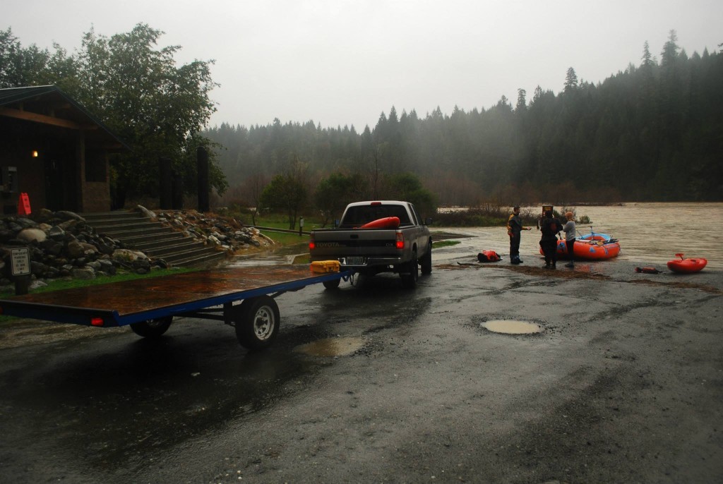
So I had planned this trip for over a week. A month and a half ago I had just run the same stretch at 12000. The trip had been very successful, and I was hoping for a chance to see it a little higher. Looking at the weather forecast and reading the discussions every 12 hours I was pretty confident that the Illinois would be at least as high as our last trip, probably higher, and this was what I was looking for. At first I was thinking about 15k, then 20k, then 30k. Friends were trying to convince me not to attempt it. I considered this, but the fact that we had run it so well at 12000 less than two months prior sealed my decision.
The day before our planned run the storm hit. It was an epic rain storm in the Southern Oregon area. Not only was there a lot of precip, but it all came down quickly. We had over four inches of rain in less than 12 hours near my house in Williams, and this usually means about triple in the coast range. The river rose quickly to 27000 cfs Friday afternoon, but as quickly as it rose it started to fall. Our plan was to catch the river just after the peak to miss most of the wood, but unfortunately this would mean running at night, which wasn’t going to happen. I really wanted to see the Illinois at a higher level than last time. A couple friends of mine, Quin and John, met me at my house Friday night, and we drove to our shuttle drivers house, “Bearfoot Brad”, in Gasquet that same night. Brad and his wife Jamie are the most hospitable people I know, and have always left their door open for this soggy, wet paddler. After drinking a few beers and listening to the rain start coming down again, we all felt a slight hope that the river would start on the rise again.
4:30 AM. Brad wakes up, turns on the computer, and starts his daily routine. Looking at weather forecasts, and prepping his daily report. He reports the level of the North Fork Smith every morning at 8 AM and has been doing it for decades. It was hard to sleep with a highwater Illinois trip looming over my head. So, sleeping on Brad’s couch, listening to him type away, eventually I got up. After I woke up I was elated, and a little sick, the river was rising again. 21000 cfs and rising. Also, over the course of the past 48 hours word of our trip had spread and there were more than three of us ready to go that morning. Over the course of the night more had showed up…
While I had been sleeping I had missed a few calls while I was sleeping from my good friend and soon to be backseat rider Kelsey. He had been stuck at the California border for over an hour and some people had been there for over 3. This was bad news. We had to drive that way, and if he couldn’t get to us, we couldn’t get to the river. We had no idea what was going on, but fortunately Brad’s wife Jamie works for Cal-Trans. One phone call later we found out a power line was down. “Well,” I said, “surely the power company will be out there soon to fix it. We should just pack up and go.”
I left with the boats to start rigging and another vehicle stayed back to wait for Kelsey who surely would be not far behind. Well, we got to the border, and traffic was stopped. We made fun of a guy who instantly jumped out of his car and started walking down the road. An obvious looky-loo. Then we made more fun of him when he started running back towards his car. Surely they are letting traffic through now, and he didn’t even make it to the front. He got in his car and drove around the truck in front of him into the other lane. “Huh,” we said, “what is he doing?” Well, he kept going, and then traffic started coming the other way. Apparently a couple truckers had found a 20 foot tall tree top that had broken off in the wind and were holding the sagging powerline up out of the way. Thank you truckers!!! We drove under the powerline and we were headed to the river. And this is how our trip started…
This trip started small and grew over time, and should have shrank if I would have listened to my conscience. (Crossroads #1) But, everyone who was on this trip at least called themselves “Class V Guides”, whether this was on Burnt Ranch, Cherry Creek, or their experience had evolved into boating in water not normally run by anybody. But, the fact remained that I didn’t know everyone, and I should have, and will in the future demand that…
We had 11 boaters and 6 boats when all was said and done. Myself, and my friend Kelsey would take the medium boat and play safety for George and Shawn who were to R-2 a smaller green boat. Matt, Kim, and Tim were to R-3 a large boat, Ryan rowed the smallest boat, Quin rowed the orange boat I had taken last time, and John rowed a larger boat with Hiya riding a backseat. It took us a while to get things organized with this many people.
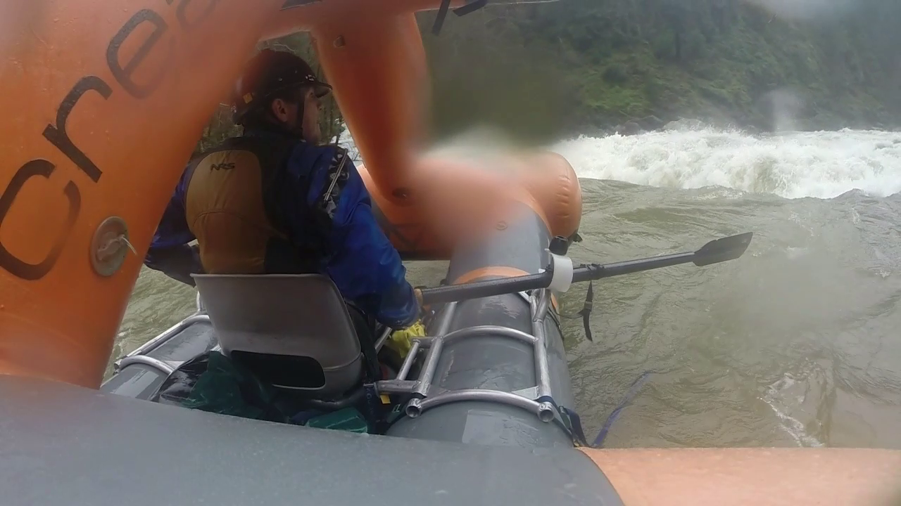
It is amazingly hard to explain to people, even experienced boaters, what the water is like in this situation. People are severely disappointed if you tell them to come back when the water is lower. It surely is a knock to the ego, and who are you to say what type of boating they should do. Creature Crafts are great boats, and they allow us to explore water that would normally be out of the question. However, they are just boats, and people have gotten into a lot of trouble with the thinking that the boat replaces skill, or even that you can just strap in and go along for the ride. We had all excellent boaters on this trip. Some had been on the 12000 trip, others had not, I knew most, but not all. Everyone performed to the best of their ability, and every boat had some mishaps. We all stuck together, and we made it out. However, for me, personally, I made a pact after that trip not to go on these types of trips again with people I hadn’t boated with fairly extensively. Lesson learned.
Nonetheless, after a few hours of blowing up boats and rigging we were off. It was about 12:30 PM. The first 12 miles were fairly uneventful if you tried to stay out of the features. Matt tested his boat out in a enormous wave and was flipped right off the bat. He was in an R-3 setup and was unable to roll, but eventually he figured it out. R-3 set ups are great if everyone is together, but it exposes your paddlers to the river, and this is not always a good thing. His two paddlers, although experienced, had never seen this type of water. Panther Creek to Clear Creek seemed similar to last time. Bigger waves (15’+), large laterals, and the center for the most part was the place to be. There weren’t too many big holes, but the laterals, and the boils really messed with you. My friend Kelsey who was riding in my backseat was stoked. I was still nervous, and it was a ton of work to maneuver the boat. I told him not to get too stoked, we haven’t seen the big stuff yet.
We made it past Clear Creek Rapid, my nerves eased, and I began letting my guard down after that. (crossroads #2) At 12000 the rapids from here until Fawn Falls were fairly inconsequecial. It appeared that it would be the same again as we moved down river. There was a large lateral coming off the left bank in rapid #27. I thought it would be fun to ride that lateral from left to right. We hit the lateral and I pulled back on the oars. We accelerated back to the right and we were all good. Unfortunately at the end of that lateral a large wave slapped the boat from the right and I flipped. Kelsey and I did not get the boat back over very fast. Perhaps 30 seconds passed until we reflipped and this was right before dropping into one of the biggest and most retentive holes on the river.
The hole was one of the strangest features I had seen, and I was able to get one good forward stroke in before we dropped into the meat. It swallowed our boat, and we spent a very violent minute or two mostly underwater. I had the ride of my life along with Kelsey in the backseat in rapid #29. Don’t flip above that rapid if you think you’re going to have a hard time righting your boat back upright. We surfed on our top for a LONG time. Eventually we would bounce up and do a barrel roll just long enough to get a partial breath and get sucked back under water. Our feet were out of the foot cups since we had just rolled a couple seconds before dropping in. This may have been part of the issue with the boat. Also I was in the Rescue Craft which is outfitted for a motor. Part of the back floor is cut out. Not sure if this would be part of the issue of upside down surfing or not.
It is a moment that I still remember vividly, both the thoughts that went through my head, and the darkness that enveloped us. I can’t say for sure how long we were in there. There were multiple boats waiting for us to come out, and I heard anywhere from 1 minute to 2 minutes. I feel it was more like one minute. Near the end, or what I thought might be the end of us, we were sucked down and everything got really dark. Kelsey and I both thought that was it, but somehow we ended up in our boats on our side, and floating downstream. My vision was quite blurry, and my muscles were cramping up. One oar was bent, the other was tangled up in the boat, but somehow Kelsey and I made it to shore. We regrouped with the rest of our party and took a 20 minute break. John gave me some beef jerky. It was good.
After Pine Flat Rapid, which was just a middle hole/wave feature we drifted for quite a few miles with little to worry about. Eventually we made it to Fawn Falls which was more forgiving than at 12000, but there were still some weird features on the left. The Green Wall was easier initially as the hole on river left was not nearly as retentive, but the eddies at the bottom were very strong, and the waves were just as erratic, with a huge lateral at the bottom coming off of the right wall.
George and Shawn got stuck in the river left eddy. My boat and Quin’s got stuck in a roomadoom on river right in the middle of the pinch point. It was very violent in there. I remember Quin and I looking at eachother and Quin yelled, “We’re in a really bad spot”. I was thinking the same thing. John’s got flipped in the Green Wall, was on it’s side entering the pinch point and kept going. Ryan chased him down. Matt made it through and eddied out on river right. Quin and I circled in that room for a while. The water seemed like it was going by about 60 mph. With some communication between our two boats somehow we both got out, but only after I was slammed into the wall backwards which forced a front flip out into the current.
After I got out of the room I eddied out on river left near a waterfall and started the process of hiking upriver to find George and Shawn. This was going to take a while, and I was preparing myself for an overnight stay. However, when I was about a 100 feet above the river I saw them pass by. They got out on their own, but kept going. The river was not going to let them eddy out. By the time Kelsey and I got back in the boat they were well downstream and out of sight. We got into our boat and let Quin know we were going. We played safety for Quin, so he led. It’s full on from here on with huge waves, laterals with some big holes to mix it up for the next 3 miles. There is a huge rock on the left of the Little Green Wall that was nearly covered, and as the surges of the river rose and fell, the feature would change. It was one of the scariest, and most awesome things I’ve ever seen. I’m pretty sure this was the biggest, and most continuous piece of whitewater I had seen yet, and on a scale of 1 to 10 as far as what creature crafts can handle I’d rate it an 8. That’s making me feel like I’m underrating it. Every corner I’d pass I was dreading seeing George and Shawn as I knew that meant something had gone wrong, but at the same time I kept hoping we’d catch up to them. Right before Collier Creek we found them eddied out and safe. I was relieved, and we kept going looking for John and Ryan. We eventually caught up to them about 3 miles downstream. We all regrouped, and knew we had made it. When we got to the takeout the water was nearly up to the campground.
There were a lot of lessons learned on this trip. I am happy that we all survived this trip, and I don’t regret embarking on it. My boating skills grew for sure, but most of all I learned about group dynamics, and who I can rely on when on the water. Every person on this trip pushed the limits of their boating skills and despite what you might feel on decisions here and there it’s just too easy to make that call afterwards. It took me a long time to watch any footage of our trip down the Illinois that February without getting sick to my stomach. At the time of writing this, nearly 8 months later, it is still a great reminder to me of the power of water, and my boating practices have certainly evolved. However, if the Illinois comes up to 20,000+ again, I can guarantee I will be considering another trip.
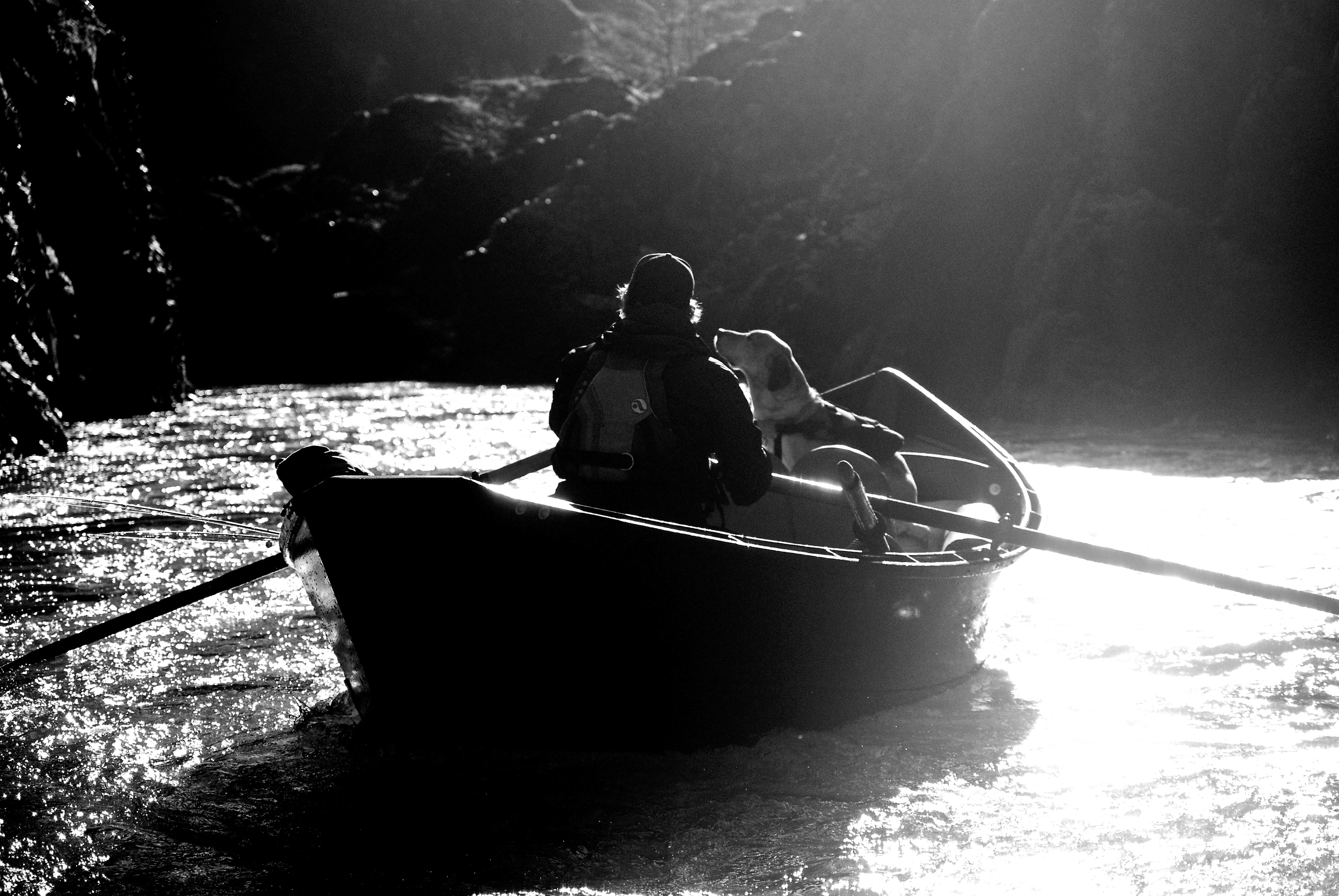
Mike Dearing picked me up in Ashland and rowed me down the river. Aaron Lieberman and Roger Goth met us at Tyee on night one and then we camped at Upper Tacoma on night two. As if to hammer home the fact that Southern Oregon has missed out on winter, we took Bear Camp back and did not see a speck of snow. Bummer, but also nice to shorten the normal winter shuttle.
We did get some rain but it wasn’t a real winter storm. The Rogue is beautiful in the winter, but I miss the ice.
Mile 1 on the Wild & Scenic Rogue RiverRoger Goth and his dog, Tyee, floating through Mule Creek CanyonAaron Lieberman headed downstream on a sunny winter day
I hesitate releasing my beta on this run because a written description doesn’t do justice to the truly violent, and unpredictable nature of this river at flood stage. I certainly don’t want to convince someone to run this simply based on what I have written, and the intelligence of my choice to attempt this run at 12000 cfs is debatable.
I’m not a good kayaker, and I can’t imagine attempting this run in a round boat, or a cataraft. The risk of a flip is nearly 100%, and a swim would be extremely dangerous. So for myself and my friends on this trip, we used Creature Crafts for our boat of choice. They performed well, and everyone made it safely to the takeout. So this write-up is here not to convince, but just to give you my perspective of what the Illinois is like at 12k.
So here it goes…
I’m sitting at home closely following the weather updates. This is not unusual for me this time of year. A big storm had come through the day before, and I had actually been planning on driving north to run the NFMF Willamette the next day. The storm was intense, and I had a feeling that my plans might change. That night I did change my mind, last minute (at about 11 PM, both because of flows, and a late night facebook message from Jamie Camden), and I decided to run the Illinois. The Illinois at highwater had always intrigued, and scared me. About 3000 cfs was the highest I’d seen it and it was well over that. It was forecast to peak over 10000, but after talking with Darren Vancil, I learned there was a good crew lined up and so I committed.
The next morning…
I am super nervous, and excited.
My main concerns were entrapment issues. Wood was certainly on my mind, and it was floating by as we rigged boats. We weren’t going to have time to scout much, and so we would be reading and running this river pretty much from start to finish. I had the obvious rapids in my mind as ones to watch out for big holes, The Green Wall, York Creek, Rocky Drop, and then of course all the rapids between Little Green Wall and Submarine Hole. But honestly I was most concerned with wood in the river and not being able to stop in time.
I had double, triple, quadruple checked my boat for everything I’d need and packed overnight gear just in case. I didn’t plan on staying overnight, the river would be moving fast, but plans are only a prediction and I had no idea what lay ahead.
I was reminded of my first trip on the Illinois. We’d be reading and running everything, but this time there wasn’t anyone else to let me know what was coming up. I had the most trips on this particular river, and so I was elected to lead. Not that I was really going to be able to give much beta though. Darren Vancil, the inventor of Creature Crafts, and one of the better boaters I know would be in the back as a safety boat with my friend Dylan Little riding a backseat. Two additional people I had just met, Matt Cronin, and Sara Weimar, would be in two different boats in the middle.
The river was certainly intimidating, moving about 10 miles an hour in an area that is normally flat and still. We put on the river at McCaleb Ranch and we pretty much had to jump in our boats and catch an eddy about a quarter mile downstream before we could really tighten up. We regrouped from there and set off.
Less than a quarter mile downriver I got my first wake-up call near the beginning of the “Deep Gorge”, with a huge lateral off the left, and a stompy curling wave, probably about 6-8 feet high that stopped me in my tracks. It wasn’t the size of the wave, but it the power, and it set the intensity for the rest of the trip. Honestly, I had some deep thoughts going on in my head after that on whether I should pull out or not. The water seemed extra powerful, even angry, and after hitting that wave I felt like I had just been in a 15 mph car accident.
However, I decided to continue at least until Miami Bar to make up my mind, knowing that the more intense rapids were just a few miles beyond.
The next 6 miles went by fast, and as we passed the normal put-in at Miami Bar I firmly decided to continue. I was starting to get a better feel for the water, and I was feeling comfortable with the movement of my boat. Passing a torrential Briggs Creek the river swelled even more, and as most would expect, around the corner at Panther Creek, the rapids grew.
From Panther Creek to Nome Creek the rapids become one. It was an intense moment for me. The river was flowing fast, it was very pushy, and other than guessing which rapids would be bigger than others, I was pretty much reading and running the entire way. It was like playing Tetris, trying to line up all the laterals, boils, and waves to move your boat, all the while accelerating to the next corner. Then you round the corner and it’s a reset. At the beginning I was mostly concerned about wood, but I soon realized that the river is so wide, that wood would not be a problem. There were few obstructions in the center, and I don’t think we ever saw any wood floating over 20 or 30 feet in length.
Waves were not unreasonable for our boats (about 10′ – 15′ max) and if it wasn’t for the fact that I had no idea what lie at the bottom of the rapids they would have been fun. On this day, however, I was all about good lines and so some early maneuvering was key. Other boats were able to play around some. Darren and Dylan ended up doing a backflip in one the larger waves on the left of Labrador Creek Rapid that I avoided like the plague. The end of Labrador Creek rapid the river turns and constricts. It is very erratic, but there is a good eddy to catch on the right just above Nome Creek.
The rapids seem to ease up until Rapid #17, followed obviously by Rapid #18 aka (Rocky Drop Rapid). Rocky Drop had been one I worried about. However, although it did have some big waves and holes, is was actually fairly easy, and the rock that normally poses a problem at lower flows was well underwater. Rapid #19 was more difficult, but still didn’t pose much of a problem. It had a lot of erratic waves that were hard to predict, and I felt like I was in some sort of boxing match with the Illinois. There is a large hole in the middle bottom of #19.
The rapids continue with little break through Rapid #22 (aka York Creek Rapid). Getting closer to York Creek I wanted to end up running right and the two rapids above York were not cooperating. Again, however, York was relatively easy. Matt ran left, I ran right, and in the end we both made it just fine. There is a large recirculating hole on the left bottom, however, and so I think in the future I’ll keep running right.
After a brief calm section we entered Rapid #23, followed closely by, you guessed it #24, or Clear Creek rapid which was very erratic, and foamy. The bottom of the rapid pulled my boat down into the water nearly up to my chest level. After this section things started to calm down and we were allowed a little bit of rest. Pine Flat is still a campsite at this level on both sides, and the rock that normally splits the river is just a large standing wave in the center.
Bottom of Clear Creek.Pine Flat Camp
The water below Pine Flat again calms, but there are lots of big pulls to make to escape eddies, and a few comparably smaller rapids. I was worried about some of the normally class 3 rapids in this section, but they proved to not be consequential. There are some fun play holes, and the river gives you a chance to get your bearings again.
The action picks up again when you approach Fawn Falls. At this level you must start pulling right early. One of the nastiest holes on the river at this level exists on the left bank at Fawn Falls and it is hard to avoid if you don’t pull early. Sara went into this hole and fortunately Darren and Dylan in the bigger boat were there to push her out. I can’t iterate enough to set up early and be proactive on your rowing.
Fawn FallsLooking down at the Green Wall
After you make the pull, stay right to enter the Green Wall. We eddied out left above the wall to regroup after Sara’s encounter with the Fawn Hole, and we were stuck again pulling hard right to avoid another nasty hole at the left entrance to the Green Wall. Scouting would be possible above the Green Wall, (I’ve thought about setting up to take pictures here), but the fact that the most dangerous features lie well below the Green Wall rapid makes scouting worthless. If you’re at this point and don’t feel like going on, stop, set up a makeshift camp and wait for the water to go down. Once you commit to the Green Wall you won’t have much of a chance to stop until Collier Creek.
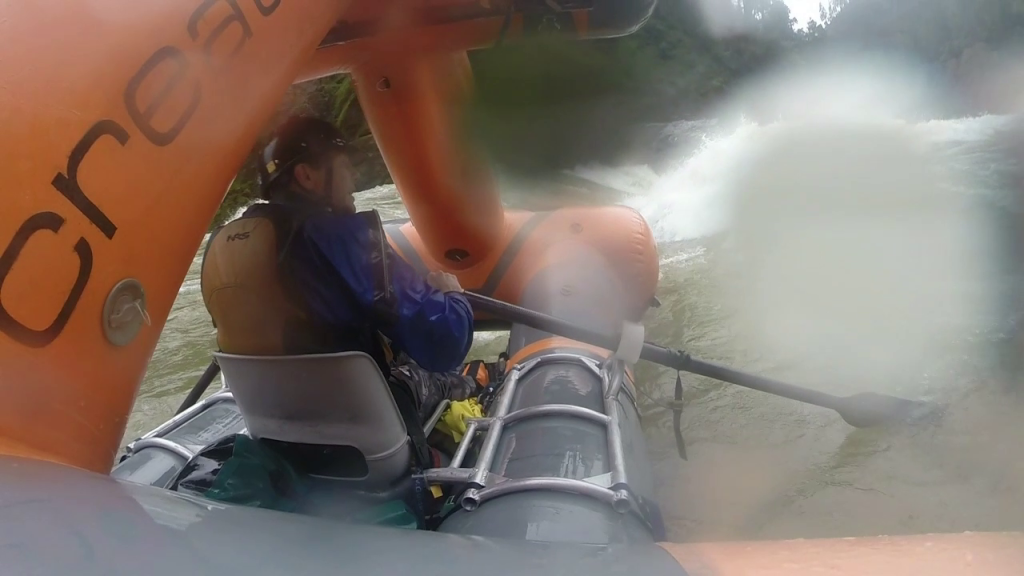
The Green Wall was still the “big one”. It is crazy to me that we just ran this one blind, but we all knew that we didn’t have time to scout, nor would it have been effective. It was the shortest day of the year, and we would be doing a couple nights out here if we wanted to scout all the major rapids. Plus, we really didn’t know if some obscure rapid, like rapid #29 in Quinn’s book, (more on that in the 20000 cfs version), would be the big one or not. Plus, in order to scout a lot of the rapids you would have to pull out a mile upstream and hike down because there were so few eddies. So, we decided to run everything without scouting, unless we could see an obvious reason, and I still think that was a good decision.
Pulling out of the eddy above the Green Wall and approaching the entrance I could see a huge hole near the top of the rapid that covers 3/4 of the river on the left side. As I began to approach the hole I was able to see the beginning of the rapid, and I think I yelled some expletives. Just past the hole, a large ramp into a 20 foot tall wave starts you out and then it’s all white as far as you can see. A large lateral coming from the left seems to combine with that big wave intermittently and so the wave seemed to move. At this point I was committed to the run and decided to charge the wave, hoping that in combination with the left lateral, it would move me right. I didn’t line up correctly, and at the top of the wave the left lateral flipped me on my side which didn’t give me any power to keep moving right.
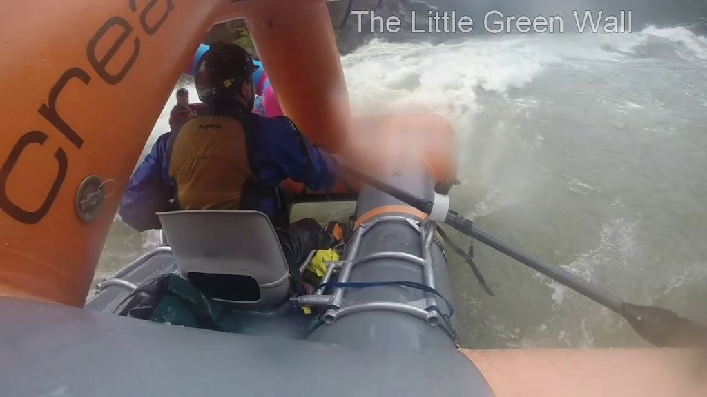
Little Green Wall
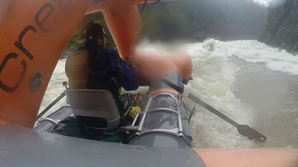
When I righted back up I was little disoriented. I looked back up to check on the other boats, they were fine, and then realized I was heading towards an outcropping on the left side of the river and entering the left side of the wave train leading into it. I kept fighting right, another wave popped up and surfed me further left, and in a last ditch effort I tried to surf the pillow in front of the outcrop. Coming up on the pillow, facing upstream, the river grabbed the front of the boat and rolled me end over end. Fortunately away from the outcrop and into the center of the river.
Here the cliffs seem to close up and some very powerful currents form what I now call the “pinch point”. The water moving downstream from the Green Wall builds here and is then forced through a narrow slot. At 12000 it seems like just a fast moving eddy, but at higher levels the currents become extremely erratic and powerful. After the “Pinch Point”, my goal was generally work towards the inside of the corners, and I was fine. There are few eddies, so if you need a break, don’t pass them up, it’s a tiring section. It is pretty much one big rapid from “Little Green Wall”, to “Submarine Hole”. Until Collier Creek there are 15+ foot waves, strong eddy lines, and large holes. I was backflipped in Submarine Hole Rapid by a random wave that seemed to just emerge right in front of my boat in relatively calm water. It was very tiring, but I would love to run that section again at the same flow now that I have seen it at least once. It’s scary, and a workout, but it’s a lot of fun.
Backflipped at Submarine Hole.
After you see Collier Creek enter from the left the river calms, and just before this point I remember grabbing my head with my hands and breathing a sigh of relief and exhilaration.
The river peaked around 12000 at Kerby an hour after we put on, and it took us about 4 hours to complete the 36 miles from McCaleb Ranch to lower Oak Flat. Did I say I was tired? Overall though I had a great experience on the river, and I am looking forward to running it again.
This was supposed to be a two-day Illinois trip, but on Friday night it dumped rain and the water shot up and over 6,000 cfs. We woke up in the morning and decided to run the Green Bridge stretch of the Illinois to Six Mile Access. The miles went by quickly and soon we were back in Selma waiting for Sunday to arrive. The water dropped through the night and in the morning it was falling below 3,000 cfs. Launched from Miami Bar and we got to Oak Flat take out just before dark and then took Bear Camp back over. All in all a tiring trip but worthwhile!
Erik Sol and crew headed downstream.Rafting the Illinois River in Southern Oregon
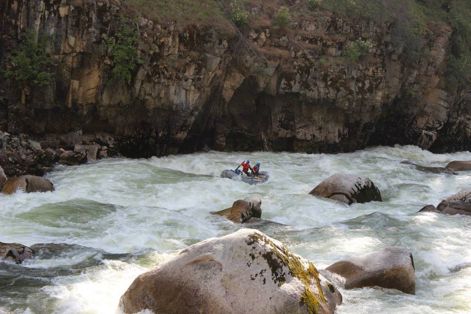
If Panther Creek was in California, Oregon or Washington this would be a coveted whitewater run. Instead, the creek is tucked away near the Frank Church Wilderness in Idaho. Spending my summers in Salmon this stretch is more feasible to run, but still a long drive.
From Salmon, drive to the town of North Fork via US-93 North, at the town turn left on to the Salmon River Road. From North Fork it’s about an hour to Panther Creek. The creek flows into the Salmon river on river-left. Follow an old dirt mining road up the creek for about 20 miles. You will definitely know when you get to the big section. It’s about 2 miles long, two distinct class V rapids class, and daunting.
We spent a long time scouting the run. The only eddy is between the big rapids. It was important to note all the big features and ensuing moves. Wasn’t pretty, but we made it down. Stoked to do it again next spring. At low water Panther Creek is an excellent dry fly creek, comparable to Fly Fishing on the Middle Fork Salmon
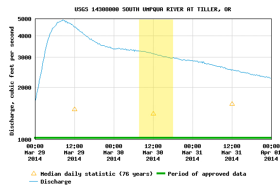
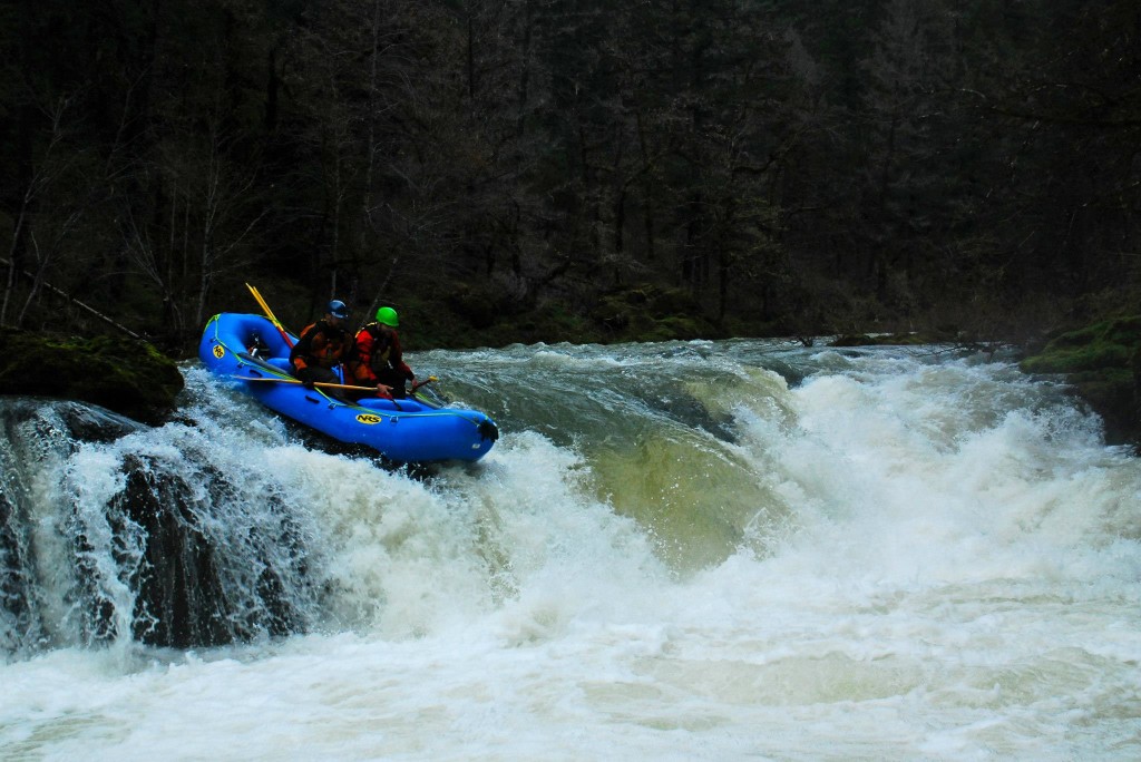
I hadn’t been on the South Umpqua before this trip so I’m not sure what a good flow would normally be. We had 3000 – 3500 at Tiller (it had been raining a fair amount) and that felt to be a medium+ flow. Put in at South Umpqua Falls, which is really a weird, long slide. The river for the most part is flat and class II, but there is the occasional horizon line that got the juices going. The highlight of the trip was Campbell Falls.
Adam Elson and WIllie Long run the slide at South Umpqua FallsAdam Elson and Willie Long run Campbell Falls on the South Umpqua
For the boatmen, for the thrills, but really just for the rivers
We use cookies on our website to give you the most relevant experience by remembering your preferences and repeat visits. By clicking “Accept All”, you consent to the use of ALL the cookies. However, you may visit "Cookie Settings" to provide a controlled consent.
This website uses cookies to improve your experience while you navigate through the website. Out of these, the cookies that are categorized as necessary are stored on your browser as they are essential for the working of basic functionalities of the website. We also use third-party cookies that help us analyze and understand how you use this website. These cookies will be stored in your browser only with your consent. You also have the option to opt-out of these cookies. But opting out of some of these cookies may affect your browsing experience.
Necessary cookies are absolutely essential for the website to function properly. These cookies ensure basic functionalities and security features of the website, anonymously.
Cookie
Duration
Description
cookielawinfo-checkbox-analytics
11 months
This cookie is set by GDPR Cookie Consent plugin. The cookie is used to store the user consent for the cookies in the category "Analytics".
cookielawinfo-checkbox-functional
11 months
The cookie is set by GDPR cookie consent to record the user consent for the cookies in the category "Functional".
cookielawinfo-checkbox-necessary
11 months
This cookie is set by GDPR Cookie Consent plugin. The cookies is used to store the user consent for the cookies in the category "Necessary".
cookielawinfo-checkbox-others
11 months
This cookie is set by GDPR Cookie Consent plugin. The cookie is used to store the user consent for the cookies in the category "Other.
cookielawinfo-checkbox-performance
11 months
This cookie is set by GDPR Cookie Consent plugin. The cookie is used to store the user consent for the cookies in the category "Performance".
viewed_cookie_policy
11 months
The cookie is set by the GDPR Cookie Consent plugin and is used to store whether or not user has consented to the use of cookies. It does not store any personal data.
Functional cookies help to perform certain functionalities like sharing the content of the website on social media platforms, collect feedbacks, and other third-party features.
Performance cookies are used to understand and analyze the key performance indexes of the website which helps in delivering a better user experience for the visitors.
Analytical cookies are used to understand how visitors interact with the website. These cookies help provide information on metrics the number of visitors, bounce rate, traffic source, etc.
Advertisement cookies are used to provide visitors with relevant ads and marketing campaigns. These cookies track visitors across websites and collect information to provide customized ads.