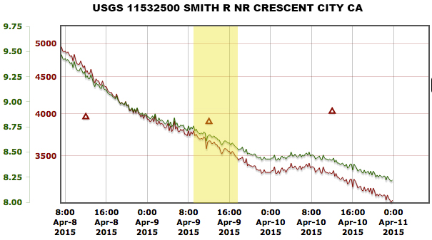
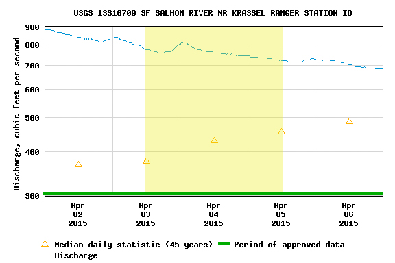
Zach Urness had been bugging me about getting back on the North Fork of the Smith. We had low flows but beautiful weather. The gauge above shows flows at Jed Smith, which are reported in CFS and Feet. This is a different gauge than the one Bearfoot Brad reports (which is at the actual confluence of the NF and MF Smiths) but the one above is the official USGS gauge. The gauge at the mouth of the NF is a foot gauge that is meant to correlate with the USGS gauge at Jed Smith. However, isolated weather events can throw this correlation off, in which case it’s best to use Brad’s gauge.
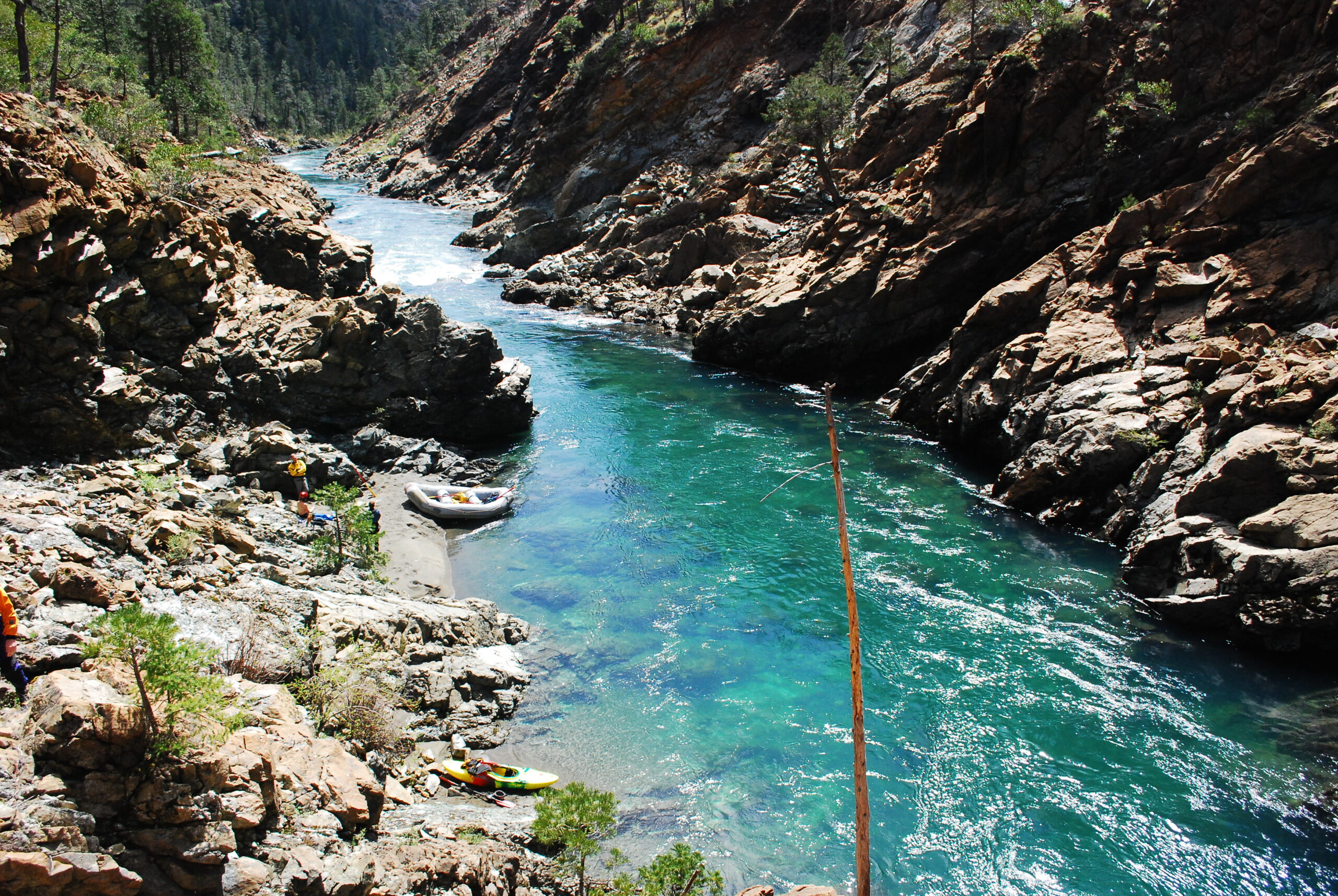
Looking down at Golf Course RapidThe North Fork Smith is a beautiful canyonLooking downstream from the shuttle road
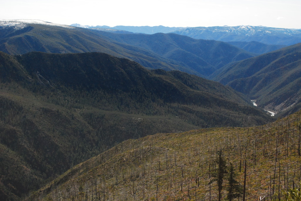
The level was 3.69 Ft. Guides from the Middle Fork of the Salmon River decided to check out the other side of the Frank Church. Andrew Wilkin, Kevin Widerman, Colin Hughes, and Josh Edmunson. We did a 3 day, 2 night raft trip. First night we Camped at mile 14.7 on river left, above Mule Kick. Second night at the confluence of the Main Salmon. 14ft boats are a perfect size raft for this level. Enjoy the report below!
For Oregon Boaters, I would compare the SF Salmon to the Illinois. It’s a run I’d describe as “land of the giants,” big holes lurking, huge horizon lines, and long continuous rapids with necessary moves. Similar to the logistics of the Illinois, the remoteness, shuttle, and changing flows make it difficult, but very doable for those who are motivated!
I would recommend 2.5ft to 3.7ft. Anything above 3.7, be careful.
Once you have the gauge figured out, then you should organize a shuttle. Google the shuttle companies in the area, or call a friend from McCall.
I like to break the SF into 3 sections. The first section is the put-in (confluence of the Secesh river) to Mule Kick rapid (mile 15). Second section, Mule Kick (Mile 15) to the Saw Mill (Mile 23), then the Saw Mill (mile 23) to Fall Creek rapid (Mile 32), the last big rapid on the South Fork.
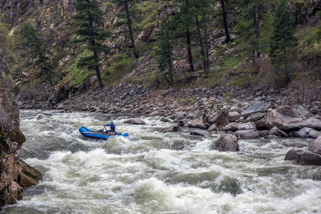
Section 1: From the put-in to Devils creek, be on your toes, lots of fun class III-IV boogie water. In no time you’ll be at Devils Creek, the first significant rapid at Mile 9. Scout on the left. Devils creek is a tricky rapid, which has a history of wood being stuck in it. Make sure you scout and really inspect the last part of the drop. After Devils Creek, is a continuous set of read and run class III-IV. Be alert and ready to make moves, some rapids you will just have to just square and push through the big hits. Around mile 14ish is a stretch of sand bar camps on river left. Nice spot to stay, above the next set of rapids.
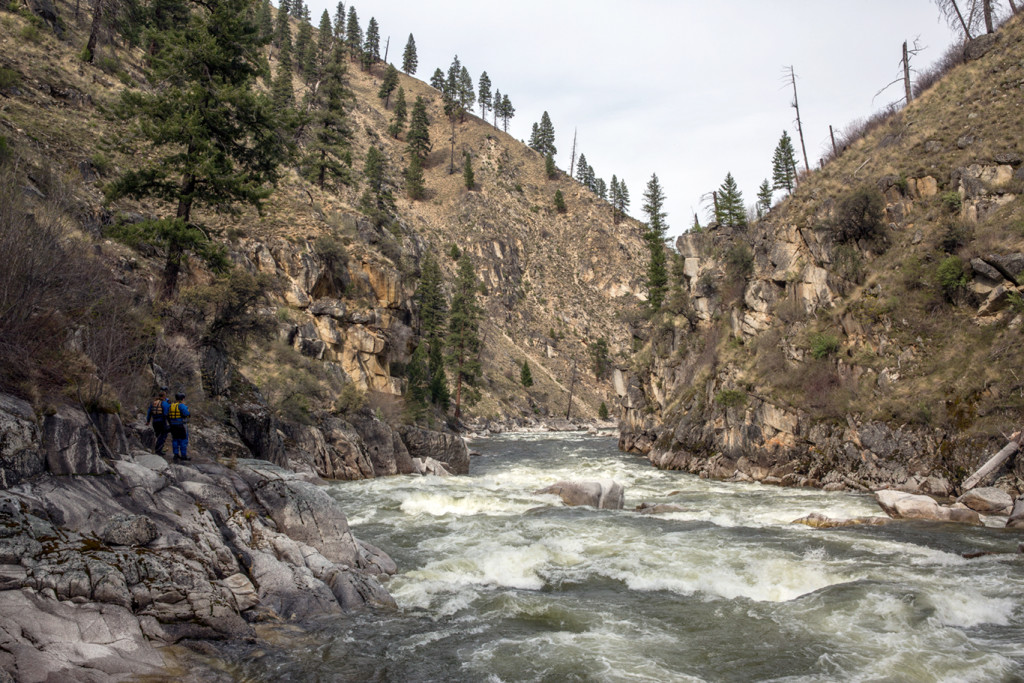
Entrance to Devil’s Creek. Photo by Skip Volpert.Devil’s Creek on the South Fork Salmon. Photo by Skip Volpert.
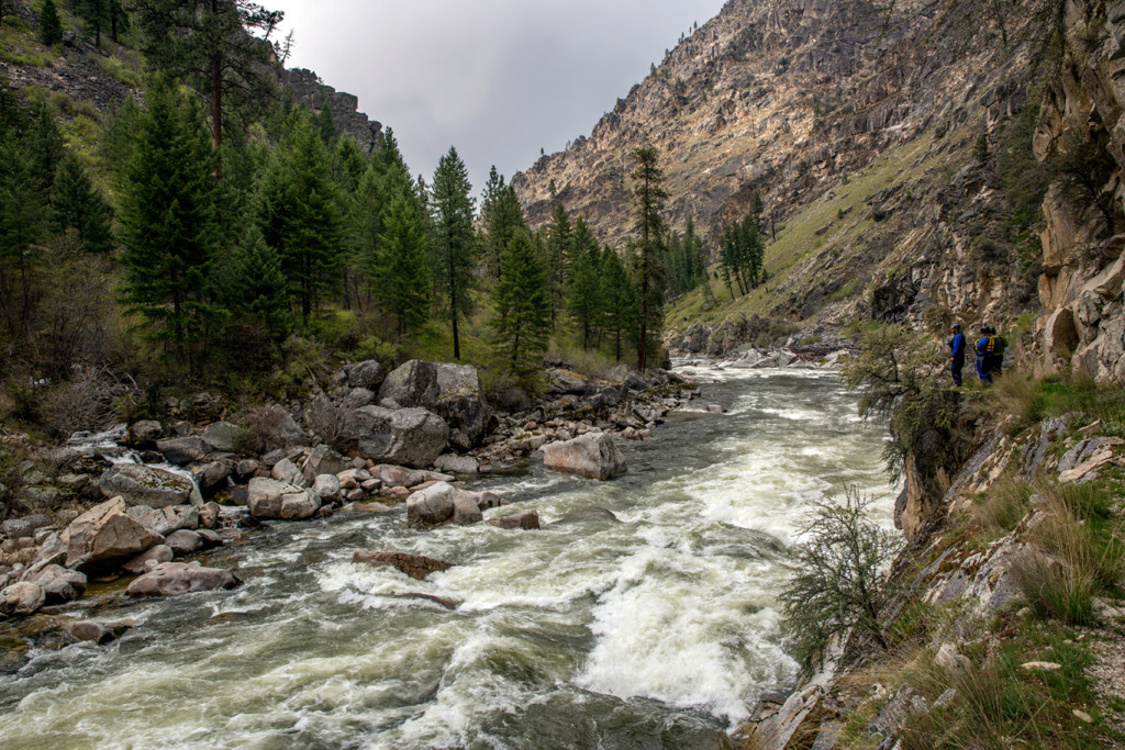
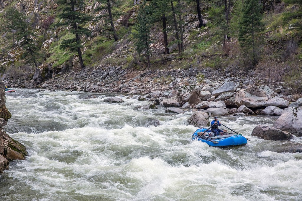
The second section: Mule Kick (mile 15) to the Saw Mill (mile 23). It’s tough for me to remember all the names of the rapids, just know there’s a plethora of rapids. I would recommend scouting most, if not all of them. Scout Mule Kick on the left, there’s a big pool above. Make sure to look for an eddy on river left below the rapid, Elk Creek is around the corner. Below Elk Creek is a spicy noodle plate of rapids. Be careful, hit em straight.
The Sawmill at Mile 23. Photo by Skip Volpert.
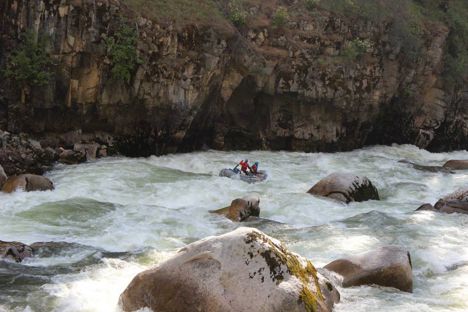
The third section, the Lumber Mill (mile 25ish) to the Confluence (mile 36.2). As the river begins to mellow, below Grouse Creek, you’ll notice a huge sawdust burner [note: we originally called this a “steam boiler” (see Ken’s comment at bottom of page)] on river left. Awesome structure to explore and check out. Note, the first rapid below the lumber mill is a technical class IV-V rapid. Far left is a undercut. No Bueno. Go center. After a couple more fun rapids the canyon will begin to narrow and you’ll be entering the last big section of the SF, buckle up!
Once you enter the canyon the gradient will increase significantly. Lots of rapids. Near the end of the stretch, is Monumental rapid (mile 31). Run hey diddle diddle right down the middle, some big hits to be had. This is a key rapid to note. Below monumental rapid is the scout eddy for Fall Creek. The scout is on the right, there’s small sandbar with a noticeable trail.
First part of Fall Creek. Photo by Skip Volpert.
Fall creek is a 3 part rapid. You will want to scout all the drops. Once you push off in your boat it can be difficult to stop above the last drop. The Main Salmon confluence is at mile 36.4. You can spend the night at the confluence, and then float out the next day. Note, you’re not allowed to camp on the Main Salmon. From the confluence to the Main Salmon take-out is 23 miles. Drink beers and celebrate good times!
Making the move in the first part of Fall Creek. Photo by Skip Volpert.Success! Photo by Skip Volpert.Last drop in Fall Creek. Photo by Skip Volpert.
For the boatmen, for the thrills, but really just for the rivers
We use cookies on our website to give you the most relevant experience by remembering your preferences and repeat visits. By clicking “Accept All”, you consent to the use of ALL the cookies. However, you may visit "Cookie Settings" to provide a controlled consent.
This website uses cookies to improve your experience while you navigate through the website. Out of these, the cookies that are categorized as necessary are stored on your browser as they are essential for the working of basic functionalities of the website. We also use third-party cookies that help us analyze and understand how you use this website. These cookies will be stored in your browser only with your consent. You also have the option to opt-out of these cookies. But opting out of some of these cookies may affect your browsing experience.
Necessary cookies are absolutely essential for the website to function properly. These cookies ensure basic functionalities and security features of the website, anonymously.
Cookie
Duration
Description
cookielawinfo-checkbox-analytics
11 months
This cookie is set by GDPR Cookie Consent plugin. The cookie is used to store the user consent for the cookies in the category "Analytics".
cookielawinfo-checkbox-functional
11 months
The cookie is set by GDPR cookie consent to record the user consent for the cookies in the category "Functional".
cookielawinfo-checkbox-necessary
11 months
This cookie is set by GDPR Cookie Consent plugin. The cookies is used to store the user consent for the cookies in the category "Necessary".
cookielawinfo-checkbox-others
11 months
This cookie is set by GDPR Cookie Consent plugin. The cookie is used to store the user consent for the cookies in the category "Other.
cookielawinfo-checkbox-performance
11 months
This cookie is set by GDPR Cookie Consent plugin. The cookie is used to store the user consent for the cookies in the category "Performance".
viewed_cookie_policy
11 months
The cookie is set by the GDPR Cookie Consent plugin and is used to store whether or not user has consented to the use of cookies. It does not store any personal data.
Functional cookies help to perform certain functionalities like sharing the content of the website on social media platforms, collect feedbacks, and other third-party features.
Performance cookies are used to understand and analyze the key performance indexes of the website which helps in delivering a better user experience for the visitors.
Analytical cookies are used to understand how visitors interact with the website. These cookies help provide information on metrics the number of visitors, bounce rate, traffic source, etc.
Advertisement cookies are used to provide visitors with relevant ads and marketing campaigns. These cookies track visitors across websites and collect information to provide customized ads.